Good both coasts tomorrow morning, Surf Coast thereafter

Victoria Forecast by Craig Brokensha (issued Monday 4th April)
Best Days: Both coasts Tuesday morning, Surf Coast into the afternoon, Surf Coast Wednesday morning, Thursday morning and Friday morning, Surf Coast all weekend
Recap
The weekend played out pretty much to plan with a good strong building W/SW groundswell Saturday under a brief period of W'ly winds around Torquay before onshores moved in shortly after, writing off the rest of the day.
Sunday saw a large and powerful W/SW groundswell peaking across the coast with solid 6ft+ sets on the Surf Coast and 8ft+ waves on the Mornington Peninsula, but early moderate to fresh onshore winds created average conditions.
Winds eased through the morning though, allowing conditions to improve on the protected reefs across the Surf Coast and also seeing great competition waves for the final of the Rip Curl Pro.
Today much cleaner conditions were seen across all coasts with a light morning offshore wind and easing swell from 3-5ft on the Surf Coast and 6ft on the Mornington Peninsula.
This week (Apr 5 – 8)
On the back of the weekend's strong frontal activity we'll see the surf continue to ease through tomorrow, with fresher local offshore breezes, swinging more NW through the day ahead of a late afternoon onshore change.
The Surf Coast should ease back from 2-3ft with 4-5ft sets on the Mornington Peninsula.
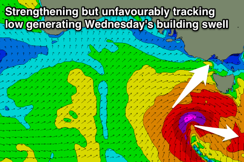 Into Wednesday we'll see a tricky mix of W'ly and SW swell from an unfavourably tracking but strengthening front/low moving in through the Bight over the coming days.
The initial SW fetch created by the front under WA will be aimed into SA and not through our swell window, but as the system moves east, it is forecast to dip south-east directly south-west of us, aiming a fetch of gale to severe-gale SW winds through our swell window.
This should produce a moderate pulse of SW groundswell, building through Wednesday ahead of a peak into the afternoon/evening.
The Surf Coast will only be around 2-3ft early at exposed breaks like 13th Beach, kicking more to the 3-4ft range through the mid-late afternoon, with the Mornington Peninsula building from 5ft more to the 6ft+ range.
Winds will be best for the Surf Coast, with a morning W/NW breeze, shifting W/SW through the middle of the day.
The swell should then ease Thursday from 3ft and 5-6ft respectively under morning W/NW winds again.
We'll fall in between swells Friday morning, but the Surf Coast shouldn't drop below 2ft+, with 3-5ft waves on the Mornington Peninsula under W/NW to W/SW winds.
This weekend onwards (Apr 9 onwards)
From the middle of this week through the weekend and early next week we'll see a procession of strong but not overly significant polar fronts through our swell window as a strong node of the Long Wave Trough stalls across Tasmania.
With the back to back frontal activity we'll see back to back moderate to possibly large pulses of SW groundswell from this Saturday through most of next week.
The first pulses for the weekend look the best at this stage, with Saturday seeing two separate swells, peaking into the afternoon/evening to 4-5ft on the Surf Coast and 6-8ft on the Mornington Peninsula.
Conditions are looking great for the Surf Coast with a a N/NW tending W/NW breeze Saturday, while NW tending W/NW winds are due Sunday ahead of a late SW change, as the mix of swells ease slowly away.
Sunday afternoon's change will be linked to another burst of weaker but closer frontal activity towards the state, producing a fresh pulse of consistent SW groundswell for Monday to 3-5ft, easing quickly through the day. Winds are due to linger from the SW, with an early W'ly likely around Torquay, but we'll have a closer look at this Wednesday.