Slow weekend, large powerful swells mid next week

Victoria Forecast by Craig Brokensha (issued Friday 25th July)
Best Days: Sunday afternoon, Monday, Tuesday, Wednesday and Thursday west of Melbourne
Recap
The beach breaks especially east of Melbourne fared best yesterday and into today with small to moderate amounts of inconsistent W/SW groundswell and N/NE winds. This afternoon we should see winds swinging more N/NW across all locations, so make the most of the current clean conditions across the Mornington Peninsula.
This week and next week (Jul 26 onwards)
The surf should lift ever so slightly through tomorrow as a long-range W/SW groundswell fills in, but don't expect anything above 1-2ft on the Surf Coast with 3ft to occasionally 4ft sets on the Mornington Peninsula. Winds will only be favourable for locations west of Melbourne though with a NW tending W'ly breeze.
Sunday afternoon's kick in long-range and inconsistent W/SW groundswell is still on track, with this swell being generated in our far swell window west and then just south of WA. Due to this, there'll be extremely long waits between sets, with the Surf Coast due to build to a very infrequent 2-3ft into the afternoon with 5-6ft+ sets late in the day on the Mornington Peninsula.
Winds will be great for the Surf Coast all day, with a fresh but easing N/NW wind, while the Mornington Peninsula should also see winds tend N/NW during the day, opening up fun options across selected breaks. This swell should hold into Monday morning before tailing off slightly into the afternoon under N/NW tending NW winds.
Of greater importance to us is the run of swell due into next week and this will be all related to a strengthening node of the Long Wave Trough pushing east across the south of the country during the weekend and then over us mid-week.
This will initially steer a couple of vigorous mid-latitude fronts under WA and through the Bight through the weekend, with a medium sized pulse of W/SW groundswell due through Tuesday off this initial activity.
This should provide more consistent 3ft waves across the Surf Coast with 6ft+ sets on the Mornington Peninsula all day Tuesday.
Into Wednesday and Thursday though things will really heat up as an initial broad and strong frontal system pushing through the Bight and then towards us Monday produces an initial strong W/SW groundswell for Wednesday morning as well as an active sea state for a much stronger and more favourably aligned polar front to move over.
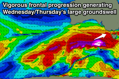 This polar front is forecast to project a fetch of severe-gale W/SW winds under the whole of Australia up towards us (steered by the LWT), producing a large and powerful W/SW groundswell that should build strongly into Wednesday afternoon and hold Thursday morning.
This should see the Surf Coast building to 6-8ft later Wednesday afternoon and holding a similar size through Thursday with the odd bigger sneakers at Bells/Winki. The Mornington Peninsula will be huge and in the 10-12ft+ range for the most part.
There is still a little model divergence around the timing of the peak/size/arrival of this swell so you'll have to check back Monday for a much clearer idea on this.
Winds at this stage look good for the Surf Coast with strong NW tending W/NW winds Wednesday and similar if not stronger winds Thursday (creating tricky conditions). Large levels of swell are expected to continue into the end of the week and start of the weekend before tailing off as the frontal activity subsides. Winds may go dicey as a ridge of high pressure moves in, but we'll cover this all again Monday. Have a great weekend!