Make the most of Saturday; much of next week looks onshore

Sydney, Hunter and Illawarra Surf Forecast by Ben Matson (issued Friday 16th March)
Best Days: Sat: flukey south swell at south swell magnets, with early NW winds.
Recap: Easing S’ly and E’ly swell offered 3ft sets on Thursday morning, before size dropped a little into the afternoon. Today we’ve seen much less consistent surf out of the south, and a small intermittent NE swell too, though set waves have still managed 2-3ft at times. Winds were light N’ly early Thursday ahead of freshening trend prior to a S’ly change in the evening, and we’ve seen lingering S’ly winds for most of today, dropping out a little into the afternoon. A new long period S’ly swell is yet to appear (though wasn’t expected until very late at the earliest).
Today’s Forecaster Notes are brought to you by Rip Curl
This weekend (May 17 - 18)
The new long period swell modeled to arrive later today should push through overnight and provide a full day of inconsistent, flukey south swell into Saturday. Only south swell magnets will pick up any energy, and it's usually the case that these acute south swells often favour a much smaller percentage of locations than normal (this swell was generated S/SW of Tasmania).
As such, exposed south swell magnets should see size around the 3-4ft mark, book-ending long periods of much smaller surf. If you're up in the Hunter, we can expect bigger surf north of 4ft and occasionally as high as 4-6ft at times, though very inconsistent. Most beaches without any reliable southerly exposure will be much smaller.
Fortunately, conditions will be clean in the morning with mainly light NW winds and moderate afternoon NE sea breezes.
A small E/NE swell is also possible throughout the day, generated by a small fetch related to ex-TC Linda, off the Far North Coast yesterday. No great size or consistency is expected however model guidance has just under a metre of swell at around 9 seconds, so NE swell magnets should pick up occasional 2-3ft sets. Don’t get your hopes up though.
The models have weakened Sunday’s freshening N’ly airstream. This is bad on several counts: it won’t necessarily translate to much better conditions (though we could see an early NW’er) however it’ll also diminish size prospects for Monday.
As such, expect easing leftovers from Saturday into Sunday, with deteriorating conditions as the northerly eventually picks up. With Saturday's south swell expected to ease steadily by Sunday morning, exposed northern ends of south facing beaches will be your best bet with occasional 2ft+ sets, occasionally bigger across the Hunter around 3ft+. Expect smaller surf elsewhere, and an easing trend throughout the day.
Next week (May 19 onwards)
Unfortunately Monday morning doesn’t look too crash hot now.
The latest guidance has the expected southerly change in overnight Sunday, and the weekend’s N’ly fetch won’t be quite as strong so we’re not looking at much surf for the early session on Monday. NE facing beaches may see occasional 2ft sets but it’ll drop quickly through the day. Winds won’t be too strong though, and will probably ease into the afternoon to become variable under the influence of a local trough of low pressure.
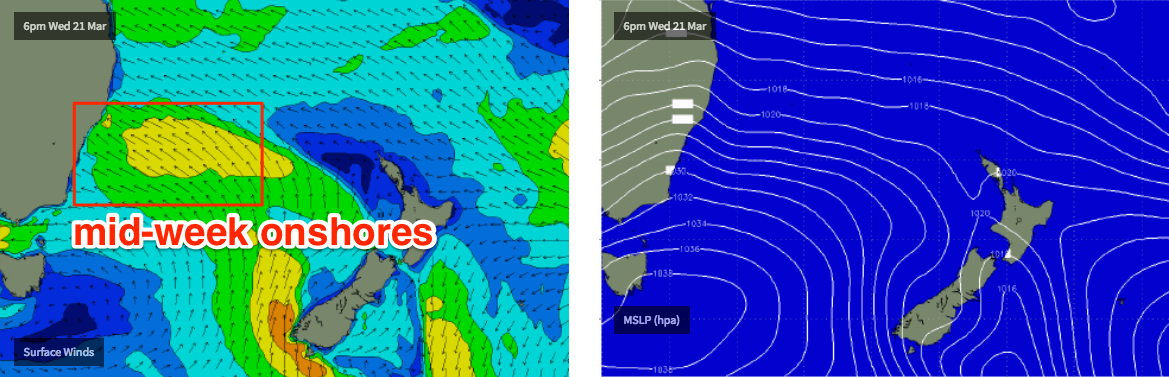
A stronger S’ly change is then due into Tuesday morning, with an associated high pressure system below South Australia pushing a broad ridge slowly up the East Coast. This will swing Tuesday's S’ly flow to the SE into Wednesday, and then E/SE where it’ll remain for the rest of the week.
Now, whilst surf prospects are active throughout this period thanks to this slow moving synoptic setup, the local airstream won’t be conducive to quality conditions at all - so right now much of the week looks pretty ordinary surf-wise for most of Southern NSW. There won’t be any shortage of size throughout this period, but you’ll have to find somewhere very sheltered.
A secondary swell source will also develop off the top of New Zealand's North Island on Saturday, generating some small E/NE swell through the first half of next week (though it'll be largely shadowed by the developing local swell).
The long term outlook into next weekend and beyond remains active with a broad fetch developing through the South Pacific mid-late next week likely contribute some E/NE swell for our region, plus a range of active systems in the Tasman Sea too.
See you Monday!
Comments
Spot on forecast for the south swell across the Hunter. Solid though inconsistent 5ft sets yesterday morning with a couple of 6ft bombs.
It’s 3ft reasonably consistent and offshore this morning illawarra
Models aren't picking it up but we could see a small sneaky south swell later tomorrow, from W/SW gales exiting eastern Bass Strait this afternoon (and a minor S'ly fetch pushing up Southern NSW tonight). Won't be until the afternoon that conditions will be worthwhile though.
Size and shape on the weekend!
Great shots Craig - first wave looks a dream.
Northern beaches really good Saturday morning, anywhere with south exposure was getting good size sets.