Small trade swell for the working week

South East Queensland and Northern New South Wales Surf Forecast by Ben Matson (issued Monday 4th April)
Best Days: No great days, but there'll be small clean beachies most weekday mornings (mainly in the north), apart from Tues which may still be a little wind affected.
Recap: Small surf across most regions over the weekend, consisting of a steadily fading south swell from early Saturday and a small lingering east swell both days. Light winds and sea breezes were on offer on Saturday, with freshening S’ly winds across northern locations on Sunday afternoon as a ridge strengthened across the Queensland coast.
This week (April 5th - 8th)
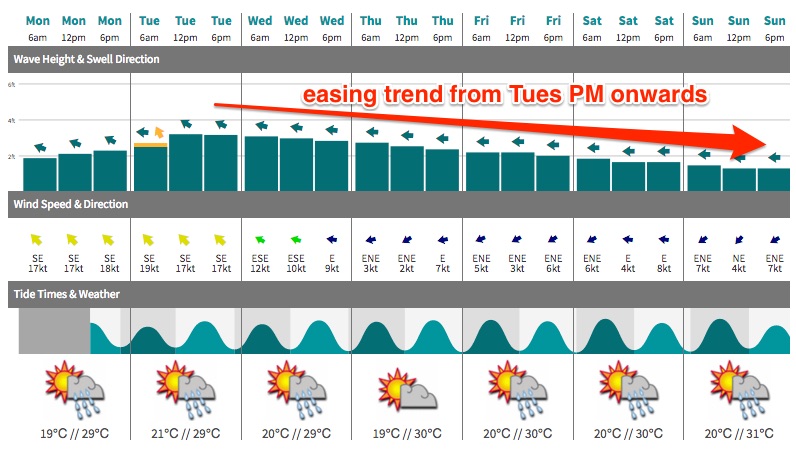
A large Tasman high extends a broad ridge across the western Coral Sea, with fresh SE winds extending from the central northern Tasman Sea up into the northern Coral Sea. This is generating a new short range SE swell that will occupy our region from Tuesday through until the end of the week.
At this stage the swell trend looks like it’ll probably peak early - around Tuesday afternoon - and then slowly peter out over the coming days, but by incremental amounts each day - the overall easing swell size assisted by a slowly building swell period, thanks to the sustained nature of the fetch. But wind speeds within the core fetch aren’t very long, so swell periods will remain generally low.
I think our forecast model has the size pretty good overall, with sets of around 3ft across the Sunshine Coast’s open beaches on Tuesday abating slowly to about 2ft by Friday (somewhere between on Wednesday and Thursday). The Gold Coast should see a smidge less size, and surf size will continue to fall away as you head south of the border.
As per usual, expect smaller surf size away from the exposed beaches (i.e. across the points and sheltered bays).
Looking into our tropical swell window, and an active monsoon trough stretching from south-eastern PNG through to Tonga has two enhanced regions of activity that are likely to spawn tropical cyclones in the coming days. However the broader pattern is moving eastwards away from our swell window - which means that we are very unlikely to see any significant swell from this source.
A broad supporting ridge to the south should generate some trade swell but it’s aligned unfavourably towards the north-west so we’ll see only small sideband energy from this (throughout the latter part of this week).
As for our southern swell window, a series of very small long period south swells will continue to glance the outer fringes of the coast, providing fleeting sets at the more reliable swell magnets. In general, the storm track is too zonal for any meaningful energy to make its way north along the East Coast (which is a shame, as some of the associated low pressure systems will be displaying core wind speeds of 50kts+) however the best of these swells - due to arrive around Thursday - may push higher than model forecast estimates.
Most days will be lucky to see much more than 1-2ft at exposed northern ends, but Thursday and maybe even Friday morning have the potential for exposed south swell magnets to rake in the odd 2-3ft set. They will be very far and few between though, and we won’t see much, if any action north of Byron Bay.
As for winds: the Coral Sea ridge will weaken from Tuesday afternoon onwards, so we can expect fresh SE breezes in the north for the next 24 hours, with light variable winds and sea breezes for Wednesday, Thursday and Friday. Wednesday will see freshening northerly winds across the Mid North Coast as a shallow southerly change approaches from southern NSW, but this is not expected to push very far north and it’ll probably leave the Northern NSW coast un an unstable atmosphere for Thursday and Friday (read: light/variable winds).
Thursday morning's southerly change (across Southern NSW) may also kick up a small short range south swell for exposed south facing beaches across the Northern NSW coast for the end of the week but no great size is expected.
This weekend (April 9th - 10th)
Hmmmm.. how can I put a positive spin on this?
The surf’s going to be very small this weekend. Again.
There, I said it.
In short: no major swell systems developing in either swell window later this week means we’ll be scrapping for leftover residual energy at the swell magnets again. The only area of interest I’ll be monitoring throughout the coming days is a weak low pressure system off the central NSW coast on Friday, which currently doesn’t look too promising, but has potential for an upgrade in the future (note: any upgrade would probably only favour Northern NSW, and not SE Qld).
Otherwise, the leading edge of a small but long period south swell is due across the Northern NSW coast - mainly the Mid North Coast - sometime Sunday, and this may be the only other opportunity to consider.
But right now, you’re better off planning to do something away from the coast. Let’s hope Wednesday’s outlook has an improvement.
Next week (April 11th onwards)
Lots of strong fronts are expected into the Lower Tasman Sea next week which suggests a lengthy spell of southerly groundswell that’ll certainly favour Northern NSW in the surf department, over SE Qld. The tropics look quiet, so it’s looking like some road trips will be on the cards over the coming weeks if you live north of the border. More in Wednesday’s updated forecast.
Comments
Not such bad news - my lower back is killing me from the last couple of months surf.....could do with a couple of weeks off.
Maybe GarryG could help you out, with your bad back, gtkimber!
He's got the bomb exercises/routines mate, trust me;)
Flick him my email gtkimber@gmail.com
Shame about the high tide, but there were some fun (albeit weak) waves this morning, 2-3ft sets and light winds. Glorious morning indeed.
A certain south swell magnet was picking up heaps of east swell this morn. Booming long lefts through the high tide with no one on them.
Don't know where you surfed this morning Ben but it was def bigger where I was. 3-4ft with one clean up bomb a solid 4ft creasing my board!!!
Regular Tweed point this morning. Long breaks of tiny, fat waves between sets, nothing bigger than 3ft for my eyes, but plenty of fun. Might have been different on low however.
I surfed from 6am to right on the top of the tide at 7:40am (when I creased my board).
But I have to admit a scout around did reveal a wide a varied range in wave heights.
I found the same down here Don (Ballina).
Some beaches looked 1-2ft while some 3-,4 and one beach well north of that.
Had a heap of fun this morning splashing around South Burleigh, warm water, plenty of sunshine and some nice clean waves coming through every so often. Crowds were well spread out as well.