Make the most of the west swell, then target the South Coast

South Australian Forecast by Craig Brokensha (issued Monday May 13th)
Best Days: Today and tomorrow both regions, South Coast Wednesday morning, Thursday morning, Friday morning and Saturday morning
Features of the Forecast (tl;dr)
- Slowly easing W/SW swell tomorrow with local offshore winds ahead of sea breezes
- Small W/SW swell for Wed with local offshore winds (bit more north in the gulf) and afternoon sea breezes
- Moderate + sized S/SW groundswell Thu with N/NE tending SE winds
- Easing swell into Fri AM, ahead of a reinforcing S/SW groundswell later and more so Sat
- Variable W/NW tending S winds Fri
- E/NE-NE tending S/SE winds Sat and light-mod S Sun
- Possible S/SW groundswell late Sun/Mon with NE tending SE winds Mon
Recap
Saturday provided good sized sets out of the south to 3ft+ on the South Coast with improving conditions under a light, variable S’ly wind, cleaner yesterday but small and fading from 1-2ft.
Today we’ve got our new pulse of W’ly swell in the water with good 2ft sets on the Mid Coast with good but not perfect conditions, though variable afternoon winds should create good conditions all day.
The South Coast is also fun with a lift in swell to the 2ft+ range with the magnets being the pick.

New swell today
This week and weekend (Apr 14 - 19)
Today’s pulse of W/SW swell is due to peak through this afternoon/evening but seeing the size already showing on the Mid Coast, the easing trend tomorrow should still maintain 1-2ft surf in the gulf.
Middleton should build to 2-3ft and ease back slowly through tomorrow from a similar size, with some small, background mid-period energy Wednesday to 2ft+ due down South with 1ft to possibly 1.5ft sets in the gulf.
Conditions look good tomorrow with local offshore winds and weak sea breezes tomorrow, similar Wednesday but with a little more north in the wind.
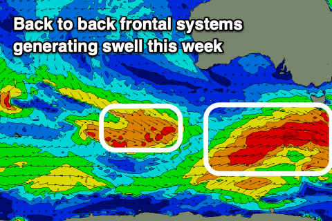
Of greater importance is the moderate sized S/SW swell for Thursday, with it being generated by the first of the more significant storms passing under the country tomorrow. A great fetch of strong to gale-force W/NW winds, followed by post-frontal W/SW winds of similar strength should generate a good swell through Thursday, easing Friday
Middleton looks to come in around 4-5ft on Thursday, easing temporarily Friday back from 4ft with the Mid Coast coming in at an inconsistent 1-1.5ft on the favourable parts of the tide.
Into the late afternoon Friday, our next pulse of S/SW swell is due, generated by a secondary similar structured frontal system moving in under the country Wednesday and Thursday.
It could be a touch stronger, but developing later in our swell window and with this, a touch less size across the state, building later Friday and peaking Saturday morning more to the 4ft range across Middleton, tiny on the Mid Coast.
Looking at the local winds and the South Coast will be great Thursday under a N/NE offshore ahead of weak SE sea breezes, variable Friday morning and likely W/NW ahead of a weak, shallow S’ly change.
Saturday looks fun but likely a little lumpy with an E/NE-NE breeze down South ahead of S/SE sea breezes, while Sunday looks dicey with S’ly winds possible from dawn.
Longer term, a third system may fire up and follow a similar track to the first two through Friday and Saturday, with another pulse of moderate sized pulse of swell S/SW due into late Sunday/Monday, but we’ll have a closer look at this on Wednesday.