Small, average week, fun on the weekend

South Australian Surf Forecast by Craig Brokensha (issued Monday November 6th)
Best Days: South Coast for the keen Thursday morning and Friday morning, Mid Coast Sunday
Features of the Forecast (tl;dr)
- Small surf tomorrow with light-mod S winds, freshening
- Building mid-period S/SW swell Wed PM, peaking Thu
- Light-mod S/SE winds, freshening Wed, light E/SE tending fresh S/SE winds Thu
- Easing swell Fri with variable winds ahead of sea breezes
- Small Sat with strengthening S/SE winds
- Moderate sized, inconsistent W/SW-SW swell for Sun with S/SE winds
- Easing swell Mon with SE tending S/SE winds
- Moderate sized S/SW groundswell for next Tue with S/SE winds
Recap
Clean conditions but tiny surf across the Mid Coast all weekend, choppy and small on Saturday down South, a little cleaner yesterday morning with a brief period of E/NE winds and lumpy 2-3ft of S/SE windswell.
This morning there was another brief window of W/NW winds and clean conditions down South with 2ft of swell, but a trough has since brought a S/SW change and bumpy conditions. The Mid Coast is flat.
This week and weekend (Nov 7 - 12)
Unfortunately the coming week is mainly poor for surfing thanks to troughy weather bringing average winds for the South Coast as the Mid Coast remains tiny in size.
Tomorrow will remain small and to 2ft across Middleton and lingering light to moderate S'ly winds will create less than ideal locations down South, offshore and clean on the Mid but flat.
A new pulse of mid-period S/SW swell for later Wednesday and Thursday is on track, generated by a weak but elongated polar frontal system that's currently south of Western Australia.
An inconsistent kick to 2ft to occasionally 3ft is due (0.5ft on the Mid Coast) but light to moderate S/SE winds on Wednesday morning will freshen later as the swell builds, with light E/SE winds Thursday morning creating doable but not great conditions for the keen.
Friday morning should offer more variable winds but with smaller, easing sets from 2ft across Middleton.
Unfortunately from the weekend we'll see the eastern arm of a strong, stubborn high sitting under Western Australia, extending over to us. This will see a persistent run of S-S/SE winds, strengthening at times as polar fronts skirt the south-eastern flank, squeezing the high.
Swell wise, there's a bit of energy due from Sunday into next week from the frontal systems pushing towards us, but then being deflected.
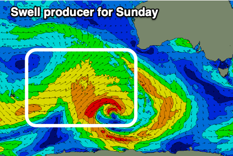
For the Mid Coast, the best swell looks to arrive Sunday, generated by an initial, slow moving frontal progression developing around the Heard Island region today. This should produce various fetches of strong W/SW winds, initially in our south-western swell window, and then more in our western swell window mid-late week.
The swell for Sunday should come in at an inconsistent 2ft across the Mid Coast on the sets, with Middleton building to 3-4ft but with strengthening S/SE winds.
Follow up swells look to be more S/SW in direction, and tiny on the Mid Coast, but we'll confirm this in Wednesday's outlook.