One chance to get wet throughout the forecast period

South Australian Surf Forecast by Ben Matson (issued Friday 17th March)
Features of the Forecast (tl;dr)
- Small clean waves down south early Saturday - that's your ONLY real surf opportunity this forecast period
- Onshore winds down south from Sat afternoon onwards
- Chance for a small wave on the Mid later Mon
- More swell potential for the end of the week; likely onshore at Victor, maybe a small wave on the Mid
Recap
The Mid's produced small 1-2ft waves for the last few days, whilst Victore Harbor has seen bigger surf in the 3-4ft range. Early NW winds swing SW on Thursday, and a brief period of light winds this morning have perked up from the south this afternoon.
This weekend (Mar 18 - 19)
There's only a brief window of opportunity for surfing this weekend, and that's Saturday morning.
A cold front is expected to cross the region before lunchtime, swinging early N/NW winds to the W/SW and eventually S/SW, before freshening from the S/SE on Sunday.
With easing size from today we'll be looking at clean though inconsistent 2ft+ sets off the point at Middleton with bigger options at the swell magnets. Once the wind swings it'll be all over.
With no new swell on the Mid this weekend we're unlikely to see anything worthwhile in the surf department. A new swell will build Sunday in the wake of the onshore change but it'll have a touch too south in its direction to benefit the gulf.
Next week (Mar 20 onwards)
We've got an excellent swell pattern due for next week, but it'll largely go to waste at Victor thanks to a sustained run of S/SE winds that'll deliver persistent onshores all week, all the result of a large slow moving high pressure sstem below the state. This is a real shame as we could be looking at 4-5ft+ sets for a period or two.. but there's simply nothing to get excited about.
There's actually two rounds of swell on the way. The first will peak Monday, sourced from a conveyer belt of fronts below the continent at the moment, and it'll slowly ease through Tuesday and Wednesday.
Thanks to the S/SW direction, I'm not expecting much swell to get nto the gulf, however a reasonable slingshot at the tail end of the fetch today (see below) is certainly far west south to benefit the Mid, though it is very south in latitude.
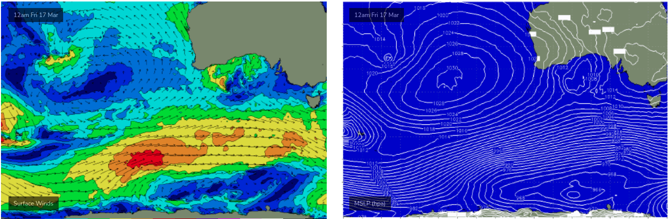
This lowers the confidence a lot, so I'm keeping my expectations very low and expecting perhaps a few stray 1-2ft sets into Monday afternoon at best. Had this fetch been positioned much further north we'd have been looking at a more westerly swell direction and thus easy 3ft+ sets.
Looking further ahead, and the long term outlook remains very active with another strong frontal conveyer belt lining up below the continent early next week that's expected to renew strong groundswells from Thursday thru' Sunday. Again, the swell direction will have a shade too much south to benefit the Mid (Victor will probably remain a write-off under persistent onshore winds) but we may see a few days of small peelers for the grommets.
I'll have more on that in Monday's update.
Have a great weekend!
Comments
So much for a breakdown of la Nina and autumn weather patterns....howling summer SE winds remain the dish nobody ordered, yet the kitchen remains closed!
Seems to me a typical start of autumn we've been waiting for. plenty of swell, shit direction, shit winds, wait till Easter to clarify shitless. Shit shit shit but hopeful
Still too early late April / may will come good. It is 37 degrees in Melbourne today. I am actually glad to see regular trades means winter should be better :)
One week either side of Anzac Day traditionally first big 30 to 40knt SW blow to bring on the change of seasons.
Up till then the SE winds will continue with high probability.
Hoping for an early start to the westerlys this year tho,