Slim pickings for the period

South Australian Surf Forecast by Craig Brokensha (issued Wednesday February 2nd)
Best Days: Keen surfers South Coast Saturday morning and more so Sunday morning
Features of the Forecast (tl;dr)
- Small S/SE windswell Thu and Fri with fresh S tending stronger S/SE winds Thu, mod-fresh E/SE tending S/SE Fri
- Slowly easing S/SE windwell Sat and Sun with E-E/NE winds Sat AM, NE Sun AM
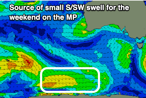
- Small S/SW swell for Sun
- Fading surf with winds from the north-east qudrant Mon-Wed
Recap
Poor junky waves with a building S'ly windswell down South and strong onshore winds, sizier today but still a mess. The Mid Coast saw 1ft of windswell kick in yesterday, fading back to 0.5ft today with cross-shore winds.
This week and next (Feb 3 - 11)
The current synoptic setup sees a strong, broad high moving in slowly from the west, muscling against a surface trough off the East Coast, bringing strong winds out of the southern quadrant.
 The high will win out and slowly continue east over the coming days, with fresh S'ly tending stronger S/SE winds, swinging moderate to fresh E/SE on Friday morning before reverting back to the S/SE and strengthening into the afternoon.
Small levels of S/SE windswell will persist to 2-3ft across the South Coast, easing through Saturday from 2ft+, with fading 2ft sets on Sunday.
Winds will improve slowly on the weekend, shifting E-E/NE on Saturday morning but best Sunday and from the NE but with the small, weak easing S/SE windswell.
There might be a small to tiny hint of inconsistent mid-period S/SW swell in the mix Sunday generated by a weak polar front that's currently skirting around the south-west corner of the high but this only looks to be 1-2ft.
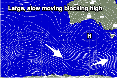 Moving into early next week the high will continue east as a surface trough deepens into a low off the Western Australia. This now unfortunately looks to sit too far north of our swell window and not bring much swell at all until it weakens and moves east mid-late week.
What it will also do is tip winds more N/NE on Monday morning, holding NE Tuesday morning and then N/NE again on Wednesday morning. Unfortunately the blocking high will prevent any major swells being generated for the South Coast with it becoming tiny.
Besides some small W/SW swell from the mid-latitude low dipping east-southeast through our swell window Friday/Saturday we might see a bit more action heading into the middle to end of the month with the Southern Ocean storm track becoming more active. More on this in the coming updates.
Comments
7 shit forecasts in a row... wonder what the all time record is, has to be close surely!
I surfed from a teenager till mid 30's then life got in the way, and have finally returned to my love of the ocean and surfing this year. What an absolute shit year to return.
I guess the upside is, any current waves i get atm are a blessing, and when we get some decent swell i will be overjoyed. In the mean time, just paddle and strengthen my arms/shoulders. Atleast I have swellnet to save me the dissapointment of driving to the coast only to see no waves. Love these updates btw. Thanks. Littlegong
Thanks littlegong, but yeah getting that fitness and when the proper waves come, you'll be absolutely frothing!