Average outlook for both coasts in most respects

South Australian Surf Forecast by Craig Brokensha (issued Monday January 25th)
Best Days: Keen surfers Mid Coast tomorrow, South Coast Thursday morning
Features of the Forecast (tl;dr)
- Inconsistent W/SW groundswell for the Mid tomorrow, fading Wed with S/SE-S/SW winds
- S/SE windswell for the South Coast Thu AM with a period of E/NE winds
- Inconsistent SW groundswell building Sat, peaking Sun AM with S/SE winds
Recap
Great waves most of the weekend down South with a mix of new SW groundswell Saturday morning and stronger S/SW groundswell into yesterday along with favourable winds. Today the swell was clean again but smaller and easing from 2ft. The Mid Coast has been just a tease and only around 0.5ft or so. An onshore change has moved through now bringing cooler weather.
This week and weekend (Jan 26 - 31)
Looking at the coming week and the South Coast will be mostly poor, with the Mid Coast likely the pick tomorrow as an inconsistent W/SW groundswell fills in. The source of this swell was a strong, though distant mid-latitude low moving through the southern Indian Ocean late last week.
Size wise we should see inconsistent 1-1.5ft sets for the most part tomorrow, with the rare 2ft'er possible on the swell magnets. Tides won't be overly favourable for any push and conditions will be a touch bumpy with a fresh S/SE tending stronger S/SW breeze, back to the S/SE late. The South Coast will be poor with a building S'ly windswell.
Wednesday will be cleaner on the Mid but the swell on the way out and only 1ft or so. The South Coast won't be too much better with gusty E/SE winds and a mix of S/SW and S/SE windswell.
Into the end of the week, a deepening inland surface trough will drift south-west across Victoria, squeezing a strong high to our south. This will generate strong SE winds in the South Coast's swell window Wednesday afternoon and evening, before the trough drifts south Thursday.
With the trough drifting south, winds will shift E/NE and there should be some fun S/SE windswell to 2-3ft or so for the keen across the magnets. Get in through the morning before S/SE sea breezes kick back in. Friday may see light W/SW winds on the backside of the trough but the swell will be at a low point and tiny.
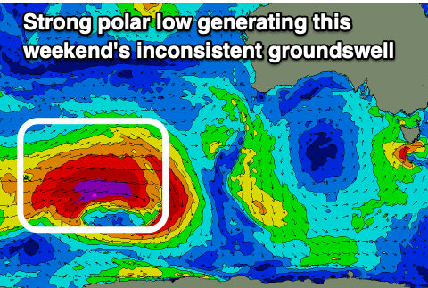 Now, as touched on last week, there's a good, inconsistent SW groundswell due on the weekend, generated by a strong polar low that's currently forming north-east of Heard Island.
A pre-frontal fetch of NW gales will be followed by severe-gale to storm-force W/SW winds, projecting east and then weakening south-west of Western Australia Wednesday afternoon.
This should produce a good, inconsistent SW groundswell that's due to build Saturday, peaking overnight/early Sunday. The swell will favour the South Coast over the Mid Coast, with building sets to 3ft due by dark Saturday, peaking Sunday morning to 3-4ft before slowly easing. The Mid only looks to see 1ft+ sets though with S/SE-SE winds, the South Coast looks poor. Monday may reveal cleaner conditions down South but we'll review this Wednesday.
There's more swell to follow but southerly winds look to dominate. Check back here Wednesday/Friday for more details.
Comments
Glad to have got a surf last weekend... Outlook looks maddening