Strong swell tomorrow, but the winds

South Australian Forecast by Craig Brokensha (issued Monday 11th November)
Best Days: Early Wednesday protected spots South Coast but more so Thursday and Friday mornings
Recap
Poor, onshore waves across both coasts on Saturday, though workable on the Mid for keen surfers, cleaner Sunday as an early onshore went variable, but the swell was on the tiny side. The South Coast was also a bit better with more variable winds and lumpy conditions.
Today is the pick though with great waves across the South Coast magnets under a hot offshore wind.
This week and weekend (Nov 12 - 17)
Our new groundswell for tomorrow is still on track, with an upgrade in size, but winds are still looking poor, with better windows of surf from Wednesday.
A strong low formed south of WA yesterday, generating a great fetch of gale to severe-gale W/SW winds while tracking east last night.
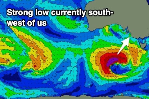 The low is currently weakening south-west of us but will maintain its strength with a fetch of SW gales forecast in our southern swell window tomorrow before it continues pushing east across Tassie. A moderate to large, long-period S/SW groundswell is expected off this low, building rapidly tomorrow and reaching 4-5ft off Middleton into the afternoon, but a front spawning off the low will bring fresh and gusty SW winds, S/SW on the Mid but with 1-2ft of windswell developing through the day.
A secondary weak front clipping us on Wednesday should steer winds back to the W/SW-SW on Wednesday, likely W/NW early around Victor with an easing mix of S/SW groundswell and mid-period S/SW swell from 4-5ft off Middleton, 1-1.5ft on the Mid Coast.
Moving into the end of the week and the coming weekend, and mid-period SW swell energy will continue to provide plenty of surf across the South Coast as back to back frontal systems move in from the south-west.
Middleton will likely still be 3ft+ Thursday morning, dropping temporarily to 2-3ft on Friday morning before kicking back up to 3ft+ Friday afternoon through Sunday. 4ft sets are most likely Saturday and Sunday morning.
Thursday looks fun with a morning W/NW breeze holding until late morning, then shifting W/SW, similar Friday but with SW winds into the afternoon. Saturday looks average as a high moves in, bringing S/SE winds, that may linger into Sunday.
The Mid Coast will remain tiny and around 1ft+ onshore until the weekend.
Longer term things should settle down into next week with easing surf with varying winds from all points of the compass, but more on this Wednesday.