Lots of swell and cold weather to come

South Australian Forecast by Craig Brokensha (issued Monday 20th June)
Best Days: Tuesday morning down South, Wednesday down South, Thursday down South, stormy haunts Friday, South Coast over the weekend
Recap
A strong building SW swell down South Saturday with plenty of waves but less than ideal and lumpy/wonky conditions under a morning E/SE breeze. The Mid Coast was cleaner but tiny to 0.5-1ft.
Sunday was much better with a variable breeze developing and persisting most of the day with solid clean waves to 3-5ft around town and off Middleton, while the Mid continued to 0.5-1ft.
Today the swell was on the ease with a light NW offshore creating good clean conditions down South, while the Mid was back to a tiny 0.5ft.
This week (Jun 21 - 24)
We've got a very active period ahead with a succession of strong cold outbreaks due to really give us that winter feeling over the coming two weeks.
Firstly the weekend's swell will continue to ease into tomorrow morning with a NW offshore down South, but this will give into a W'ly change through the day as a relatively weak mid-latitude low pushes into us.
This low is expected to kick up a small weak increase in W/SW swell across the Mid Coast to 2ft through the afternoon but with those onshore winds (easing from 1-2ft Wednesday), while a late increase in SW swell is due down South, peaking Wednesday morning to a weak 3ft at Middleton and 4-5ft at Waits and Parsons. Winds will improve Wednesday and swing from the W/NW to NW, creating fun waves at selected spots down South.
A temporary low point in swell activity is due Thursday morning ahead of a late pulse of new long-range SW groundswell and much smaller short-range SW energy.
The long-range swell has already started to develop in the Heard Island region with a vigorous polar low generating a fetch of gale to severe-gale W'ly winds.
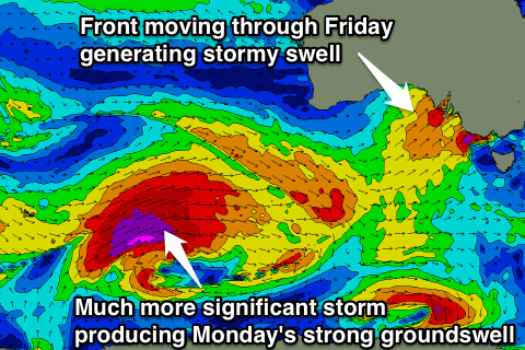
This front will continue to project north-east towards us while weakening over the coming days, leaving a good long-period SW groundswell to arrive later Thursday, peaking Friday morning.
The short-range swell will be produced by a strengthening frontal system pushing in from WA through Thursday with a fetch of W/SW gales due to be projected right into us overnight and Friday morning.
This will generate an additional stormy swell across both coasts Friday.
 Size wise Middleton should kick to 3-4ft later in the day Thursday with 5ft sets at Waits and Parsons, peaking Friday morning to 3-5ft and 6ft respectively. The Mid Coast should building surf to 2ft Thursday afternoon with stormy 4ft waves Friday.
Winds Thursday should be favourable for the South Coast all day with a gusty W/NW breeze persisting all day, while Friday looks poor with that strong SW change.
This weekend onwards (Jun 25 onwards)
Saturday is looking really fun as Friday's swells ease under a light to moderate N/NW'ly, while a reinforcing SW groundswell is due Sunday from a fetch of pre-frontal W/NW gales.
Of much greater importance is the large W/SW groundswell due into next Monday.
This will be generated by a vigorous polar low firing up around Heard Island Wednesday evening, projecting a slow moving fetch of severe-gale to possibly storm-force W/SW winds towards us right through the weekend.
We should see a large W/SW groundswell arriving through Monday peaking to a large 5-6ft+ across Middleton and 8ft+ at Waits and Parsons with strong 3ft sets on the Mid, but more on this in Wednesday's update.