Large swells this week but with NW winds

Nias, Mentawai, South Sumatra forecast by Craig Brokensha (issued Tuesday 31st May)
Best Days: Locations that can handle the N/NW breezes and large swell this week, other breaks from Sunday
This week and next (Jun 1 - 10)
A large S/SW groundswell seen across the coast yesterday is currently on the ease with large dropping surf early this morning. We'll continue to see the swell ease into tomorrow morning back to 4-6ft across exposed south facing breaks as N/NW winds persist.
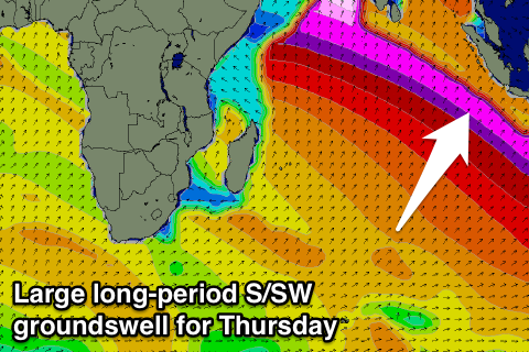
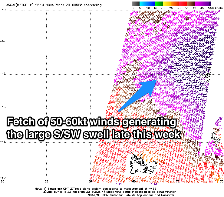 Later in the day though the fore-runners of a new large long-period S/SW groundswell are due to show, generated over the weekend and into yesterday by a vigorous polar frontal progression through the southern Indian Ocean (in a similar area to where the current swell was produced). Satellite observations confirm 50-60kt W/SW winds generated through our swell window along with open ocean seas up to 42ft.
We'll see the long-period fore-runners arrive through Wednesday at around 22s, with a late increase in size visible, with the groundswell proper filling in Thursday and reaching a strong and dangerous 10ft to possibly 12ft across exposed breaks.
This swell will ease back slowly from the 8ft+ range Friday morning, further Saturday but slowed by a reinforcing pulse to 6-8ft into the afternoon.
Sunday should see a more defined pulse of new S/SW groundswell from a strong polar frontal system currently firing up north of Heard Island and this should keep wave heights up around 6-8ft, easing slowly into Monday and Tuesday.
 Unfortunately moderate to sometimes fresh N/NW winds are due to persist across the region from Thursday through Sunday limiting surfing options, before tending SE into Sunday and early next week.
Longer term a large new S'ly groundswell is on the cards for Wednesday/Thursday from a vigorous storm developing in the Southern Ocean, but more on this Thursday.
16 day Mentawai forecast graph
16 day Nias forecast graph
16 day South Sumatra forecast graph
Comments
Hey Craig,
Heading to the Mentawais next week, just missing this week's big swell but the upcoming period still looks pretty active.
Any thoughts on the swell late next week and into the weekend? Looks reasonable.
Cheers!
Hey Stok, sorry mate, been real busy and haven't had a chance to get a Ments update up.
Looking at a slow start to early next week with background S/SW groundswell to 3-4ft+ or so but with variable winds.
A better pulse is due Wednesday to 4-5ft+, easing Thursday and then a stronger long-period S/SW groundswell Friday arvo and Saturday. Peak sets look to be in the 5-6ft+ range, easing slowly into Sunday and the following week.