Flukey swells ahead of more reliable energy next week

Eastern Tasmania Surf Forecast by Craig Brokensha (issued Wednesday 9th September)
Best Days: South swell magnets Saturday afternoon, Tuesday and Wednesday next week
Recap
A small increase in N/NE windswell yesterday, cleanest late while today there's no size left as the swell fades.
This week and weekend (Sep 10 - 13)
As touched on in Monday's update, a change moving through today has no real strength and there's no decent S'ly swell due to be generated in its wake. Instead a tiny S'ly windswell is expected tomorrow.
 Into Friday a short-lived fetch of N'ly winds don't look to generate any decent sized N/NE windswell with 1-1.5ft waves max due across the north swell magnets and with a N/NW tending N'ly breeze.
Moving into the weekend and there's nothing major on the cards, but keep an eye on the south swell magnets Saturday afternoon.
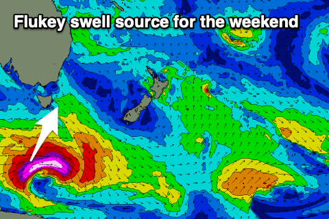
A very strong low tracking south-east through our swell window is due to produce a fetch of severe-gale to storm-force W/SW winds briefly aimed towards us.
This could create a flukey kick in size to 2-3ft on the south magnets Saturday afternoon, fading from 2ft max Sunday.
Winds look favourable and out of the N/NW all day, less favourable Sunday and out of the SW to SE as a trough slides up from the south.
 Next week onwards (Sep 14 onwards)
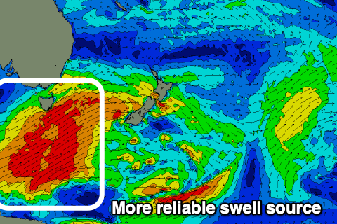
Also discussed in the last update, a strong polar frontal progression is due to move in and under us through early next week, with it projecting north-east and into the Tasman Sea.
This increases our swell potential with some fun S'ly groundswell due Tuesday and Wednesday next week with relatively favourable winds. More on this Friday though.