Fun mix of E/NE and NE swells Sunday through Tuesday

Eastern Tasmania Surf Forecast by Craig Brokensha (issued Friday 6th May)
Best Days: Sunday morning, Monday, Tuesday morning, Wednesday morning south swell magnets
Recap
Moderate to fresh NW winds and tiny 0.5ft of NE swell. Nothing to surf.
This week (May 7 - 13)
Unfortunately the weekend's building NE windswell event through Sunday and Monday has been downgraded with the infeed of NE winds into a deepening mid-latitude low over South Australia not really staying long within our swell window.
Our long-range E/NE trade-swell building slowly tomorrow and further Sunday and Monday is still on track though. A persistent fetch of E'ly trades above and east of New Zealand have been aimed through our swell window since early this week.
Now the fetch is slowly migrating south-west moving towards us, but only weak.
This will continue through tomorrow before breaking down above New Zealand through Sunday.
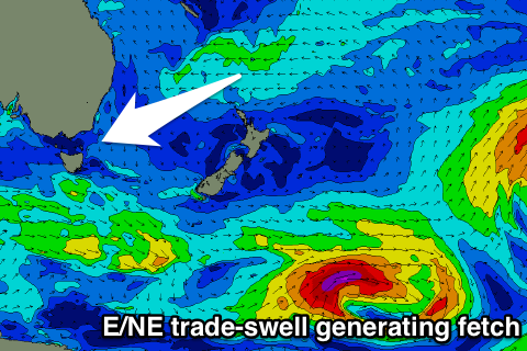 Tomorrow and Sunday the smallest and least consistent energy is due, building to 2ft tomorrow and holding around 2ft+ Sunday.
Monday and Tuesday morning should see the better pulse with 2-3ft sets, but this will be mixed in with similar amounts of north-east windswell.
Conditions will be clean tomorrow morning with a W/NW tending N'ly wind, and then W'ly tending E'ly breeze Sunday. Tuesday looks great with all day offshore W/NW winds as the swell eases.
Longer term we should see a fresh and short-lived pulse of S'ly swell for Wednesday morning from the mid-latitude moving across us and projecting a burst of S/SW gales through our southern swell window.
South facing eaches should spike to 3-4ft with morning W/NW winds, fading through the day quickly.
A stronger and broader frontal system moving over us later in the week could produce a larger S'ly groundswell for Friday, but more on this Monday. Have a great weekend!