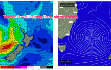
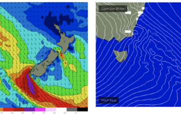
As of this morning our deep Tasman low (984hPa) is still slow moving although high pressure support has slipped in under the low with the strongest winds now aimed more at Tasmania.
Primary tabs
/reports/forecaster-notes/eastern-tasmania/2025/04/02/still-sizey-slowly-easing-tasman-low-dissipates
freeride76
Wednesday, 2 April 2025
/reports/forecaster-notes/eastern-tasmania/2025/03/31/l-xl-swells-few-days-intense-low-hovers-in
freeride76
Monday, 31 March 2025
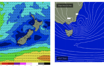
These winds will coalesce later today into a more organised fetch of S-SE gales as the system slowly tracks southwards then S/SE. As a result we’ll see elevated wave heights from the E/SE-S/SE right into mid-week, augmented by some long range S/SE groundswell from another ice shelf fetch in the Ross Sea region adjacent to Antarctica.

/reports/forecaster-notes/eastern-tasmania/2025/03/28/wild-and-wooly-period-ahead-deep-low-ne
freeride76
Friday, 28 March 2025
By Sun we’ll see a low forming off the South Coast with a strong SE infeed along the southern flank of the low. That will see strong S/SE winds through Sun and building swells from the same direction.

/reports/forecaster-notes/eastern-tasmania/2025/03/26/surf-becoming-large-over-the-weekend-low-forms
freeride76
Wednesday, 26 March 2025
We’ll see surf from this NE-E/NE infeed propagate from the sub-tropics down to temperate regions over the weekend, eventually generating swells for NETas as a surface low forms from the trough off the south coast of NSW and moves towards Bass Strait.
/reports/forecaster-notes/eastern-tasmania/2025/03/24/make-the-most-tomorrow
Craig
Monday, 24 March 2025
A good but inconsistent S/SE groundswell for tomorrow looks to be the highlight of the week.
/reports/forecaster-notes/eastern-tasmania/2025/03/21/not-much-the-weekend-some-fun-flukey-s-swell
freeride76
Friday, 21 March 2025
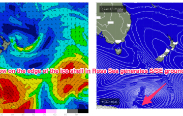
Into next week and Tues offers some potential with models picking up some long period S/SE groundswell generated by a slow moving polar low around the edge of the Antarctic ice shelf in the vicinity of the Ross Sea.
/reports/forecaster-notes/eastern-tasmania/2025/03/19/great-surf-developing-tomorrow
Craig
Wednesday, 19 March 2025
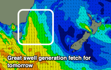
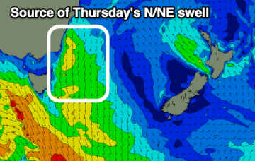
A building N/NE swell with improving offshore winds should provide great surf tomorrow.
/reports/forecaster-notes/eastern-tasmania/2025/03/17/fun-south-east-followed-north-northeast
Craig
Monday, 17 March 2025
The coming week looks to be the best of the period.
/reports/forecaster-notes/eastern-tasmania/2025/03/14/frontal-systems-bring-s-swells-and-seasonal
freeride76
Friday, 14 March 2025
SW gales push through Bass Strait and adjacent to the Tasmanian East Coast Sun night and into Mon.
/reports/forecaster-notes/eastern-tasmania/2025/03/12/pulses-the-south-ahead-seasons-shift
freeride76
Wednesday, 12 March 2025
To the south we are seeing strong, but zonal frontal activity which will impact the Island state with local winds and S swells later next week.
