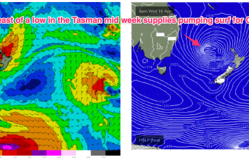
Certainly by Wed into Thurs the synoptic chart should look insane with a deep low (970-980hPa) retrograding into the Tasman, positioned inside the North island with plenty of space for severe gale to low end storm force winds to be aimed up at the east coast.
Primary tabs
/reports/forecaster-notes/eastern-tasmania/2025/04/14/surfable-options-week-pumping-surf-now-expected
freeride76
Monday, 14 April 2025
/reports/forecaster-notes/eastern-tasmania/2025/04/11/average-weekend-some-east-energy-next-week
Craig
Friday, 11 April 2025
The coming period is a bit hit and miss but the middle of next week should offer a wave.
/reports/forecaster-notes/eastern-tasmania/2025/04/09/small-flukey-swells-ahead
freeride76
Wednesday, 9 April 2025
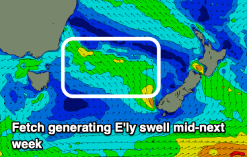
We’ll see a long E’ly fetch develop through the South Pacific slot through the end of this week, enhanced by a trough of low pressure near New Caledonia which is attached to a still active monsoon trough. Swells from this source may eventually reach NETas later next week.
/reports/forecaster-notes/eastern-tasmania/2025/04/07/small-pulses-s-swell-week-easing-the-weekend
freeride76
Monday, 7 April 2025
A front passes into the Tasman overnight and robust fetch of SW gales is trailing behind, currently sweeping NE past the SE coast of Tasmania. We’ll see a moderate S swell generated by this fetch, with a dominant high moving into the Tasman in it’s wake and strengthening through the week

/reports/forecaster-notes/eastern-tasmania/2025/04/04/slower-outlook-tricky-south-swells
Craig
Friday, 4 April 2025
Make the most of the east swell ahead of a trickier, smaller run of south swell.

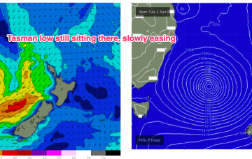
/reports/forecaster-notes/eastern-tasmania/2025/04/02/still-sizey-slowly-easing-tasman-low-0
freeride76
Wednesday, 2 April 2025
As of this morning our deep Tasman low (984hPa) is still slow moving although high pressure support has slipped in under the low with the strongest winds now aimed more at Tasmania.
/reports/forecaster-notes/eastern-tasmania/2025/04/02/still-sizey-slowly-easing-tasman-low-dissipates
freeride76
Wednesday, 2 April 2025
As of this morning our deep Tasman low (984hPa) is still slow moving although high pressure support has slipped in under the low with the strongest winds now aimed more at Tasmania.
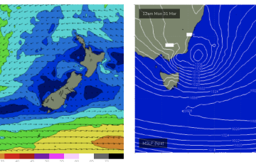
/reports/forecaster-notes/eastern-tasmania/2025/03/31/l-xl-swells-few-days-intense-low-hovers-in
freeride76
Monday, 31 March 2025
These winds will coalesce later today into a more organised fetch of S-SE gales as the system slowly tracks southwards then S/SE. As a result we’ll see elevated wave heights from the E/SE-S/SE right into mid-week, augmented by some long range S/SE groundswell from another ice shelf fetch in the Ross Sea region adjacent to Antarctica.

/reports/forecaster-notes/eastern-tasmania/2025/03/28/wild-and-wooly-period-ahead-deep-low-ne
freeride76
Friday, 28 March 2025
By Sun we’ll see a low forming off the South Coast with a strong SE infeed along the southern flank of the low. That will see strong S/SE winds through Sun and building swells from the same direction.

/reports/forecaster-notes/eastern-tasmania/2025/03/26/surf-becoming-large-over-the-weekend-low-forms
freeride76
Wednesday, 26 March 2025
We’ll see surf from this NE-E/NE infeed propagate from the sub-tropics down to temperate regions over the weekend, eventually generating swells for NETas as a surface low forms from the trough off the south coast of NSW and moves towards Bass Strait.