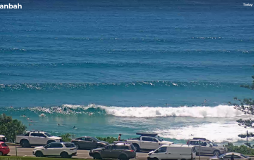
New high pressure moves SE of Tasmania to start next week and compared to Wed’s notes it’s looking stronger and slower moving, which is good news for surf potential, especially medium term as it anchors low pressure drifting down from the tropics into the wide open South Pacific slot.
Primary tabs
/reports/forecaster-notes/south-east-queensland-northern-new-south-wales/2025/02/07/upgraded-outlook
freeride76
Friday, 7 February 2025
/reports/forecaster-notes/south-east-queensland-northern-new-south-wales/2025/02/05/nice-conditions
freeride76
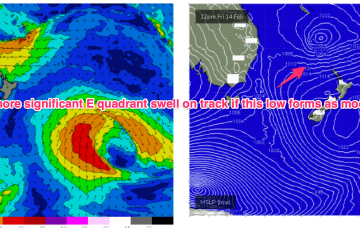
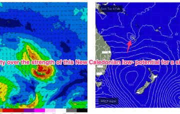
Wednesday, 5 February 2025
No great change to the outlook as a tradewind fetch anchored by tropical low pressure near New Caledonia remains active before the low slides off to the SE later tomorrow and into Fri. We’ll see continuing mid-period tradeswells from this source, slowly easing from todays peak.
/reports/forecaster-notes/south-east-queensland-northern-new-south-wales/2025/02/03/some-quality
freeride76
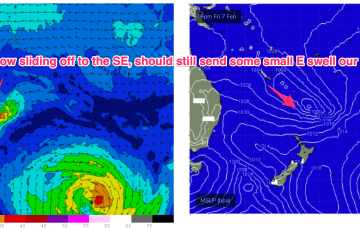
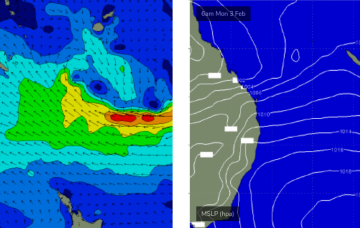
Monday, 3 February 2025
High pressure support for the tropical systems which is currently anchoring a tradewind fetch in the Coral Sea weakens substantially over the short term, with E swell potential thus weakening. We’ll still see plenty of fun E’ly trade swell in the sub-tropics but the top end potential has taken a haircut as well as the duration of the event.
/reports/forecaster-notes/south-east-queensland-northern-new-south-wales/2025/01/31/plenty-fun
freeride76
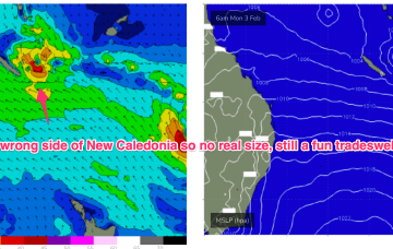
Friday, 31 January 2025
A more classic looking summer chart to start next week with high pressure in the Tasman and low pressure centres near New Caledonia and in the South Pacific slot, with a healthy E’ly tradewind fetch extending across most of the Central and Southern Coral Seas.
/reports/forecaster-notes/south-east-queensland-northern-new-south-wales/2025/01/29/extended-trade
freeride76
Wednesday, 29 January 2025
The tropics is in an active state with multiple low centres expected along the monsoon trough as it responds to a phase of the MJO passing into Australian longitudes. Still plenty of uncertainty there, with any meaningful swell subject to extremely low confidence in specifics.

/reports/forecaster-notes/south-east-queensland-northern-new-south-wales/2025/01/27/small-mixed-bag
freeride76
Monday, 27 January 2025
Multiple low pressure systems are suggested on long range model guidance, potentially tropical cyclones which could deliver large E’ly swells.

/reports/forecaster-notes/south-east-queensland-northern-new-south-wales/2025/01/24/meh-the-short
thermalben
Friday, 24 January 2025
Either way, it’s looking like our eastern swell window is about to get into the swing of things and finally resume its regular summer programming.
/reports/forecaster-notes/south-east-queensland-northern-new-south-wales/2025/01/22/complex-outlook
thermalben
Wednesday, 22 January 2025
The approaching southerly change should be getting close to the Qld border around dawn..
/reports/forecaster-notes/south-east-queensland-northern-new-south-wales/2025/01/20/tuesday-the-pick
thermalben
Monday, 20 January 2025
We’ve got plenty more swell on the way, and much better winds on Tuesday as the synoptic pattern relaxes, allowing a light variable airstream to envelop the coast.
/reports/forecaster-notes/south-east-queensland-northern-new-south-wales/2025/01/17/decent-spell
thermalben
Friday, 17 January 2025
The best low for Northern NSW/SE Qld surfers is already sitting just north of New Zealand, and is generating E’ly swells that will feed into Sunday’s mix and provide solid 4ft waves across most exposed coasts, holding into Monday.