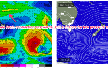
The only hope is some small E swell from a distant fetch which may see some rideable waves ta spots exposed to the Capricorn to Breaksea Spit channel opening. We’ll see some potential 1-2ft surf through Thurs/Fri and Sat from that source.
Primary tabs
/reports/forecaster-notes/central-queensland/2025/05/28/lots-tiny-surf-ahead-winter-kicks-in
freeride76
Wednesday, 28 May 2025
/reports/forecaster-notes/central-queensland/2025/05/23/just-rideable-surf-easing-more-come-medium
freeride76
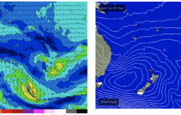
Friday, 23 May 2025
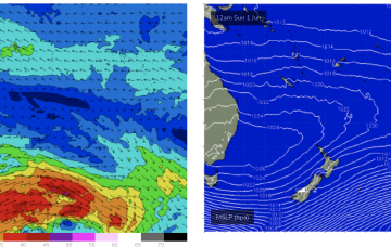
Some small E’ly tradeswell is also likely to build into the first week of winter as an E’ly fetch builds across the Coral Sea, suggesting a round of fun surf for CQ.
/reports/forecaster-notes/central-queensland/2025/05/19/small-just-rideable-surf-possible-week
freeride76
Monday, 19 May 2025
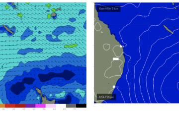
We should see some tiny, possibly just rideable surf from the system through the week, more likely after Wed as the fetch draws out into the Northern Tasman.
/reports/forecaster-notes/central-queensland/2025/05/16/surf-easing-the-weekend-nothing-much-next
freeride76
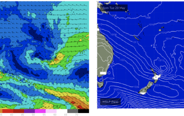
Friday, 16 May 2025
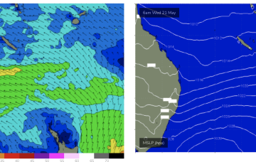
That fetch will be positioned too far south for CQ and as a result of that we’ll see mostly tiny surf next week.
/reports/forecaster-notes/central-queensland/2025/05/14/surf-easing-the-weekend-another-round-likely
freeride76
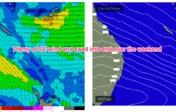
Wednesday, 14 May 2025
Weaker pressure gradients are now in the Coral Sea, as the synoptic pattern takes a pause in between dominant high pressure systems.
/reports/forecaster-notes/central-queensland/2025/05/12/surf-easing-week-another-round-likely-next
freeride76
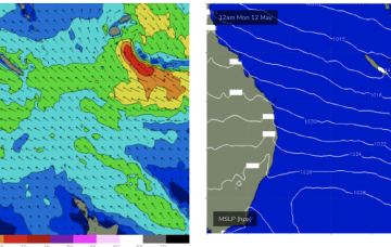
Monday, 12 May 2025
A broad trade fetch on steroids is now slowly breaking down through the Coral, Tasman and South Pacific with a tropical low whizzing away to the SE.
/reports/forecaster-notes/central-queensland/2025/05/07/lots-more-waves-ahead
freeride76
Wednesday, 7 May 2025
Big, slow moving high in the Tasman next week will slowly migrate towards New Zealand, holding a broad fetch of E’ly winds across the Coral Sea, South Pacific slot and into the Northern Tasman.
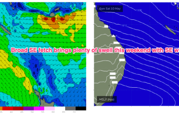
/reports/forecaster-notes/central-queensland/2025/05/05/surf-pattern-week-and-another-one-next-week
freeride76
Monday, 5 May 2025
This will drag the trade fetch southwards before another dominant high quickly re-establishes a firm ridge and SE surge on Thursday, bringing another round of SE tending E/SE swell favouring the sub-tropics for size.
/reports/forecaster-notes/central-queensland/2025/05/02/extended-run-surf-ahead
freeride76
Friday, 2 May 2025
By Mon a large high will be drifting towards New Zealand with broad fetch of E/SE-SE tradewinds in the South Pacific slot, extending into the Coral Sea and Northern Tasman.

/reports/forecaster-notes/central-queensland/2025/04/30/plenty-surf-weekend-onwards
freeride76
Wednesday, 30 April 2025
Into next week a dominant high tracks towards New Zealand and sets up a robust E’ly tradewind fetch through the Coral Sea and South Pacific, encroaching on the northern Tasman Sea at times.