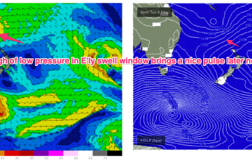
This synoptic set up is akin to a mid-strength black nor’easter, with an impressive fetch stretching all the way from Far Southern NSW to Fiji and Tonga.
Primary tabs
/reports/forecaster-notes/sydney-hunter-illawarra/2025/05/21/mid-strength-black-noreaster-the-boil
thermalben
Wednesday, 21 May 2025
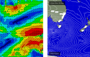
/reports/forecaster-notes/sydney-hunter-illawarra/2025/05/19/wild-and-wooly-weather-ahead-still
freeride76
Monday, 19 May 2025
A very unstable, dynamic synoptic chart this week with a large high (1034hPa) moving from the Bight through Victoria, with a coastal trough deepening off the Mid North Coast on the leading edge of the high directing very moist onshore winds across Central NSW, extending up into the sub-tropics.
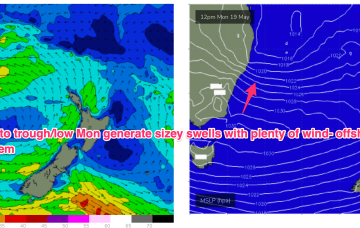
/reports/forecaster-notes/sydney-hunter-illawarra/2025/05/15/tasman-sea-gets-rowdy-next-week
freeride76
Friday, 16 May 2025
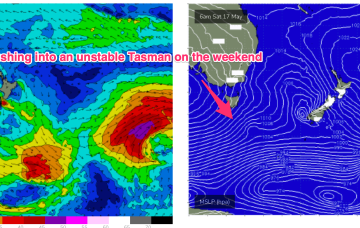
We’ve got good model agreement now that through Mon we’ll see a deep trough develop from the Coral Sea down to a terminus somewhere on the MNC to lower North Coast with good odds we will see a surface low develop at that terminus.
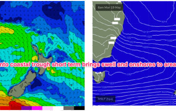
/reports/forecaster-notes/sydney-hunter-illawarra/2025/05/14/fun-beachies-continue-short-term-the
freeride76
Wednesday, 14 May 2025
Next week still looks dynamic with potential for a deep trough or low in the Tasman, although we are going to have to play it day by day due to poor model to model and run to run consistency.
/reports/forecaster-notes/sydney-hunter-illawarra/2025/05/12/clean-beachies-until-mid-week-dynamic
freeride76
Monday, 12 May 2025
The recent pattern of very strong highs moving through the Bight into the Tasman then resets over the weekend with a high likelihood of another surge of S-SE swell during this period

/reports/forecaster-notes/sydney-hunter-illawarra/2025/05/09/fun-waves-and-dynamic-synoptics-abound
thermalben
Friday, 9 May 2025
There’s actually a couple of E/NE swell sources for early next week. And a S'ly swell too!
/reports/forecaster-notes/sydney-hunter-illawarra/2025/05/07/spike-in-s-swell-short-term-another
freeride76
Wednesday, 7 May 2025
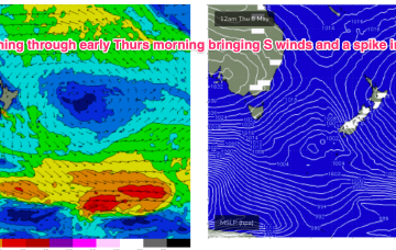
In between, a trough and cold front are currently approaching Tasmania, expected to bring a vigorous S’ly change o/night, bringing a spike in short range S swell short term.
/reports/forecaster-notes/sydney-hunter-illawarra/2025/05/05/spell-small-clean-surf-the-next-large
freeride76
Monday, 5 May 2025
We’ll see the current dominant high (1034hPa) over New Zealand which is directing a broad trade fetch through the South Pacific and into the Coral Sea slowly migrate eastwards this week with an E’ly dip form a trough of low pressure due E of SEQLD mid week.
/reports/forecaster-notes/sydney-hunter-illawarra/2025/05/02/improving-conditions-over-the-weekend
freeride76
Friday, 2 May 2025
A dominant (1034hPa) high pressure system is currently moving off the Far South Coast into the Tasman Sea where it very slowly migrates south-eastwards over the weekend. Pressure gradients weaken over temperate NSW with a firm ridge in the sub-tropics holding a S-SE pattern over the weekend.
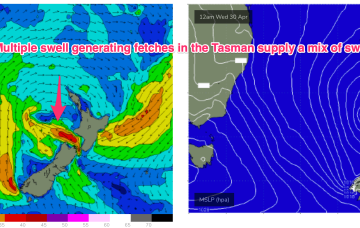
/reports/forecaster-notes/sydney-hunter-illawarra/2025/04/30/windy-s-swells-short-term-mellowing-out
freeride76
Wednesday, 30 April 2025
We’re seeing a ramp up in strong S’ly winds along the eastern seaboard as a dominant high (1035hPa) moves through the eastern Bight towards Tasmania with a trough on it’s leading edge moving northwards. Remnants of a low on the weekend are also sitting near New Zealand with swell generating fetches off the South Island and emerging from Cook Strait into the eastern Tasman.