The weekend looks great for surf with a more manageable sized swell and clean morning conditions.
Primary tabs
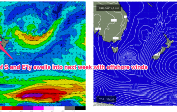
/reports/forecaster-notes/sydney-hunter-illawarra/2024/08/02/gradual-easing-in-size-the-swell-goes
Craig
Friday, 2 August 2024
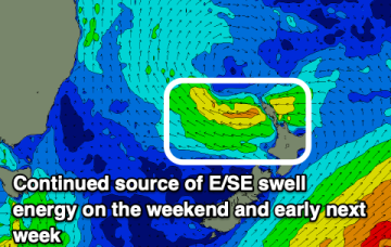
/reports/forecaster-notes/sydney-hunter-illawarra/2024/07/31/big-surf-eases-and-becomes-more
freeride76
Wednesday, 31 July 2024
No change to the outlook as a massive, slow moving low pressure system in the Tasman and strong high over Tasmania combine to fill the Tasman Sea with gales to strong gales generating L to XL surf.
/reports/forecaster-notes/sydney-hunter-illawarra/2024/07/29/significant-swell-event-under-way
Craig
Monday, 29 July 2024
The start of a significant and sustained swell event is currently underway with wave heights not settling back until next week.
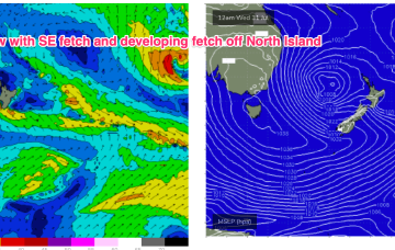
/reports/forecaster-notes/sydney-hunter-illawarra/2024/07/26/extended-period-big-surf-next-week-low
freeride76
Friday, 26 July 2024
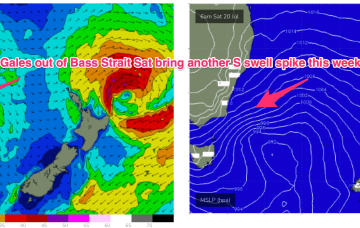
Gales to strong gales develop later Sun and o/night into Mon as a complex low forms in the Tasman. Multiple swell generating fetches are expected to form and sling shot around this huge, slow moving low gyre. Thus we can expect an extend period of large surf next week with embedded pulses from the S through S/SE-SE as the week goes on.

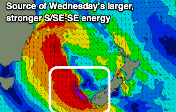
/reports/forecaster-notes/sydney-hunter-illawarra/2024/07/24/major-upgrade-next-week-strong-low
freeride76
Wednesday, 24 July 2024
With good model agreement now there’s high confidence we’ll see a major winter swell event next week as a slow moving low takes up occupancy in the Central Tasman leading to a highly energised stormy sea state over a majority of the Tasman Sea.

/reports/forecaster-notes/sydney-hunter-illawarra/2024/07/22/not-much-all-week-uncertain-outlook-next
freeride76
Monday, 22 July 2024
Following that we’ve got a spring like week ahead with only some minor NE windswell to offer up some rideable waves.
/reports/forecaster-notes/sydney-hunter-illawarra/2024/07/18/spike-in-s-swell-sun-then-flat-spell
freeride76
Friday, 19 July 2024
Much stronger S swell signal for Sunday. A trough of low pressure and front rapidly push into the Tasman. Gales will be short-lived but sufficient to whip up a spike in S swell.

/reports/forecaster-notes/sydney-hunter-illawarra/2024/07/16/s-swell-spikes-ahead-tinyflat-spell-next
freeride76
Wednesday, 17 July 2024
This is driving stiff W’ly tending SW’ly winds all the way up to the tropics - even New Caledonia is seeing this stiff SW flow! The current northwards moving low and proximate fetch will generate a quick spike in S swell before it quickly moves away with following fronts now looking more zonal and not as favourable for swell production.
/reports/forecaster-notes/sydney-hunter-illawarra/2024/07/14/slowly-easing-e-swells-multiple-s-swell
freeride76
Monday, 15 July 2024
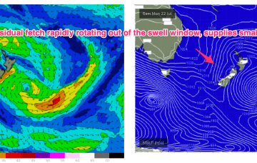
We have a deep low (985hPa) adjacent to Tasmania and another attached low centre further E in the Tasman with the long E/NE infeed into this complex low gyre focussed near the west coast of the North Island and slowly sliding out of the swell window.

/reports/forecaster-notes/sydney-hunter-illawarra/2024/07/12/strong-mix-ely-and-sly-swells-ahead
freeride76
Friday, 12 July 2024
The circulation in the trough line has increased wind speeds in the fetch as the air mass moves from high to low pressure. As a result we’ll see an increase in wave heights and period through tomorrow.