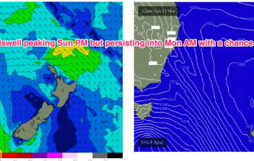
There is quite a strong front tracking across the lower Tasman in advance of this high cell, along with a polar low, which will send some useful S swells our way before the high sets up a blocking pattern, which is expected to be reinforced by another large high next week.
Primary tabs
/reports/forecaster-notes/sydney-hunter-illawarra/2024/11/19/fun-blend-swells-expected-short-term
freeride76
Wednesday, 20 November 2024
/reports/forecaster-notes/sydney-hunter-illawarra/2024/11/17/small-s-pulses-week-strongest-fri-summer
freeride76
Monday, 18 November 2024
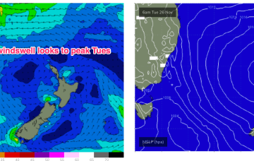
A large high is approaching from well south of the Bight and expected to occupy the Tasman from Thurs, with a more summer style wind pattern of SE-E winds in the sub-tropics and NE winds in temperate NSW. Tradewinds will supply workable swells for the sub-tropics medium term with small pulses of S swell this week favouring NSW.
/reports/forecaster-notes/sydney-hunter-illawarra/2024/11/15/increasing-ne-windswells-sun-s-pulses
freeride76
Friday, 15 November 2024
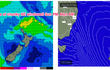
We’ll see that N-NE flow really ramp up on Sun as an approaching front and cut-off low really tightens the pressure gradient.
/reports/forecaster-notes/sydney-hunter-illawarra/2024/11/12/troughy-pattern-throwing-some-dynamic
freeride76
Wednesday, 13 November 2024
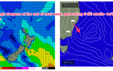
Troughiness next week does offer potential for low pressure development in the Tasman but we’ve got high model variability so confidence is very low in the outcomes.
/reports/forecaster-notes/sydney-hunter-illawarra/2024/11/10/more-swell-energy-week-tricky-troughy
freeride76
Monday, 11 November 2024
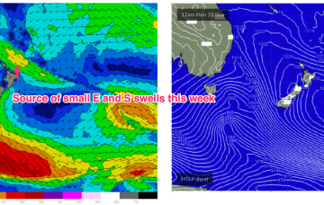
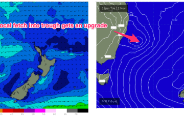
Another unstable, troughy week ahead with humid, unstable air over the continent creating a series of troughs, one of which forms a slow moving trough of low pressure off the Mid North Coast which interacts with a weak high pressure cell drifting in the Tasman. That will supply some workable E quadrant swell favouring temperate NSW.
/reports/forecaster-notes/sydney-hunter-illawarra/2024/11/07/small-and-weak-weekend-longer-term
freeride76
Friday, 8 November 2024
No change to the weekend surf outlook which remains small and weak but winds will be all over the place as a trough of low pressure hovers about the NSW central/MNC coast.
/reports/forecaster-notes/sydney-hunter-illawarra/2024/11/05/power-remains-low-and-over-the-weekend
freeride76
Wednesday, 6 November 2024
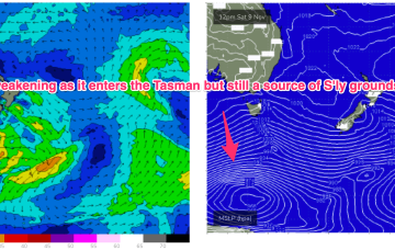
S groundswell is still on the radar as a slow moving polar low tied to Fridays front skirts the southern edge of the swell window, over the weekend.
/reports/forecaster-notes/sydney-hunter-illawarra/2024/11/03/mediocre-outlook-week-little-more-the
freeride76
Monday, 4 November 2024
We’ll be relying on some small NE windswell episodes and great circle paths under the continent to deliver some flukey S groundswell short and medium term.

/reports/forecaster-notes/sydney-hunter-illawarra/2024/11/01/mediocre-outlook-ne-windswell-sunmon-the
freeride76
Friday, 1 November 2024
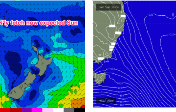
High pressure slides into the Tasman off the Central NSW coast while the remnants of a front scoot across the Tasman. The front will have generated a small flush of S swell.

/reports/forecaster-notes/sydney-hunter-illawarra/2024/10/30/grovel-days-ahead-low-energy-outlook
freeride76
Wednesday, 30 October 2024
We’re still looking at a fairly bland synoptic pattern with a weak, troughy environment in the Tasman, undergirded by zonal frontal activity well to the south. Some modest frontal activity pushes through late in the week with a developing N’ly flow on Sun set to provide some NE windswell.