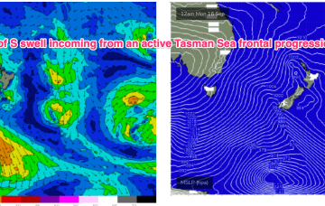
That will bring a robust S’ly change tomorrow and some workable S swell for temperate NSW, with a trough in the sub-tropics tilting the change more S/SE-SE later tomorrow into Wed.
Primary tabs
/reports/forecaster-notes/sydney-hunter-illawarra/2024/10/07/nothing-special-workable-swells-the-s
freeride76
Monday, 7 October 2024
/reports/forecaster-notes/sydney-hunter-illawarra/2024/10/04/great-weekend-strong-surf-and-favourable
thermalben
Friday, 4 October 2024
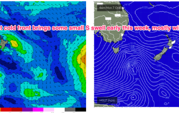
We’ve got some great waves due this weekend, with light offshore winds both days and only weak sea breeze an outside risk each afternoon.
/reports/forecaster-notes/sydney-hunter-illawarra/2024/10/02/great-period-waves-ahead-peaking-over
thermalben
Wednesday, 2 October 2024
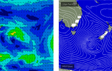
The models have marginally downgraded the developing Tasman Low generating Saturday’s large SE swell

/reports/forecaster-notes/sydney-hunter-illawarra/2024/09/30/stacks-great-surf-ahead-including
thermalben
Monday, 30 September 2024
We’ve got a dynamic outlook ahead, though the next few days look a little tricky for surf.
/reports/forecaster-notes/sydney-hunter-illawarra/2024/09/27/lighter-winds-and-e-swells-weekend
freeride76
Friday, 27 September 2024
The situation becomes dynamic again next week. The trough is expected to stall in the central Tasman with a new strong front pushing NE into the Tasman and becoming incorporated into the trough system. The system then looks to stall and intensify near the South Island, possibly even retrograding mid next week.

/reports/forecaster-notes/sydney-hunter-illawarra/2024/09/25/turbulent-period-ahead-windy-s-swells
freeride76
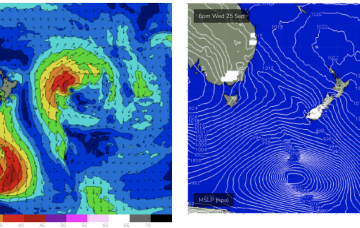
Wednesday, 25 September 2024
A robust front linked to a deep low is expected to migrate up the southern NSW coast o/night and into the wee hours, with a surface low expected to form off the North Coast as a trough interacts with the front.
/reports/forecaster-notes/sydney-hunter-illawarra/2024/09/23/more-s-groundswell-then-troughlow-in-the
freeride76
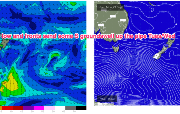
Monday, 23 September 2024
We’ve got a really dynamic outlook this week as a strong high drifts across from the Bight and a trough drawing in tropical moisture from the Indian Ocean moves across the country and eventually enters the Tasman Sea, with a long angled trough and possible surface low expected to form in the Tasman late this week.
/reports/forecaster-notes/sydney-hunter-illawarra/2024/09/19/small-s-swells-and-offshore-winds-over
freeride76
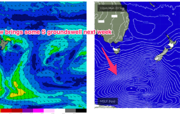
Friday, 20 September 2024
Model divergence reduces confidence in the outlook with GFS suggesting the trough deepens into a broad surface low which would bring days of elevated S through SE-E/SE swell and onshore winds.
/reports/forecaster-notes/sydney-hunter-illawarra/2024/09/17/smallmedium-s-pulses-continue-plenty
freeride76
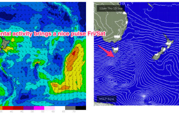
Wednesday, 18 September 2024
Frontal activity is going to generate some small S pulses in the short term with some fun waves on tap at S facing beaches. Next week we should see a stronger system move NE into the Tasman potentially generating some sizier S swell. Quite a decent outlook for September.
/reports/forecaster-notes/sydney-hunter-illawarra/2024/09/16/plenty-s-swell-short-term-easing
freeride76
Monday, 16 September 2024
After a spell of early spring heat the synoptic pattern has reversed back to a more winter style situation with frontal activity pushing into the Tasman, backed by a strong high (1040hPa) in the Bight. We’ll see this high rapidly weaken and move up over NSW and into the Tasman this week while zonal fronts continue westerly ridging below Tasmania and bring mostly offshore winds to temperate NSW.