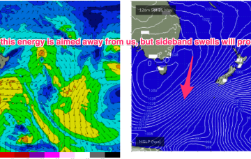
Following that a secondary front coalesces with the primary front to form a complex Tasman low which is expected to occupy the Tasman for a meaningful period of time, even retrograding back towards the East Coast over the weekend.
Primary tabs
/reports/forecaster-notes/sydney-hunter-illawarra/2024/06/12/multiple-peaks-and-valleys-series-sizey
freeride76
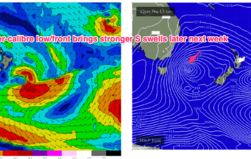
Wednesday, 12 June 2024

/reports/forecaster-notes/sydney-hunter-illawarra/2024/06/10/extended-run-large-south-swell-the-boil
thermalben
Monday, 10 June 2024
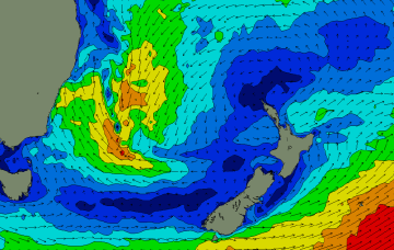
The main synoptic activity this week will be related to an amplifying node of the Long Wave Trough which is expected to slide through the Tasman Sea before parking itself across New Zealand longitudes later in the week. We’ll see a prolonged round of large to very large swell as a result.
/reports/forecaster-notes/sydney-hunter-illawarra/2024/06/07/whole-stack-south-swell-the-way
thermalben
Friday, 7 June 2024
We’ve got a complex weekend of small waves. And then a very active period from the south.
/reports/forecaster-notes/sydney-hunter-illawarra/2024/06/05/dynamic-outlook-another-low-forming
freeride76
Wednesday, 5 June 2024
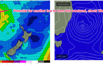
Troughy remnants remain off the North Coast and South Coast interior and these troughs are expected to deepen and reform into another surface low through Fri into the weekend with another round of E/NE infeed swell and S swell although much more subdued than last weekends swell.
/reports/forecaster-notes/sydney-hunter-illawarra/2024/06/03/easing-swells-and-offshore-winds-low
freeride76
Monday, 3 June 2024
A trough line connected to the low remains angled SW/NE in the Tasman with a N-N/NE infeed along the trough line. With the movement of the low into the coast, winds on the southern flank are now out of the swell window so we’ll be relying on the NE infeed into the trough and potential small lows forming in the trough line for swells in the short term once the current S/SE swell fades out.
/reports/forecaster-notes/sydney-hunter-illawarra/2024/05/31/dynamic-outlook-plenty-swell-ahead
thermalben
Friday, 31 May 2024
A lingering coastal trough is expected to slowly evolve into a closed circulation through Saturday.
/reports/forecaster-notes/sydney-hunter-illawarra/2024/05/29/couple-low-energy-days-dynamic-weekend
freeride76
Wednesday, 29 May 2024
Under current modelling, by first light Sat morning a trough of low pressure will be deepening due east of the Illawarra.

/reports/forecaster-notes/sydney-hunter-illawarra/2024/05/27/nice-autumn-conditions-start-the-week
freeride76
Monday, 27 May 2024
A pair of weak cold fronts are expected to pass over Tasmania in the short term, generating small S swells which will overlap with the last pulses coming from the polar low now SE of New Zealand. A dynamic, troughy pattern looks set to unfold over the weekend.

/reports/forecaster-notes/sydney-hunter-illawarra/2024/05/23/light-winds-and-s-swells-over-the
freeride76
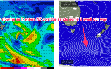
Friday, 24 May 2024
High pressure is approaching Tasmania with a weak trough expected to linger in the Tasman over the weekend and lead to mostly light/variable breezes. A complex polar low is approaching the NZ corridor and although the frontal progression looks a notch less favourable for swell production up the East Coast we’ll still see S’ly groundswell pulses over the weekend.
/reports/forecaster-notes/sydney-hunter-illawarra/2024/05/22/easing-swells-the-weekend-some-s-pulses
freeride76
Wednesday, 22 May 2024
Local swell sources dry up but polar lows better aimed at Pacific targets will send some long period S swell up the pipe over the weekend and early next week before a more subdued outlook takes hold.