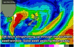
The run of persistent offshore breezes will continue throughout the week and weekend, with an easing southerly swell.
Primary tabs
/reports/forecaster-notes/sydney-hunter-illawarra/2016/05/25/clean-conditions-and-easing-sly-swell
Guy Dixon
Wednesday, 25 May 2016
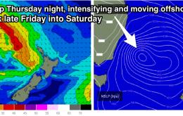
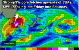
/reports/forecaster-notes/sydney-hunter-illawarra/2016/05/23/strong-sly-swell-due-peak-wednesday
Guy Dixon
Monday, 23 May 2016
The S'ly swell window looks to provide good energy, with a generally offshore wind pattern as fronts move to the south.
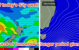
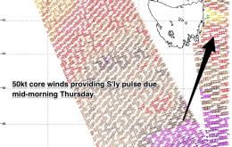
/reports/forecaster-notes/sydney-hunter-illawarra/2016/05/20/solid-sly-swell-saturday-large-sly-swell
thermalben
Friday, 20 May 2016
There’s a couple of components to the southerly swell unfolding across the East Coast.
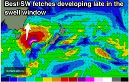
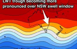
/reports/forecaster-notes/sydney-hunter-illawarra/2016/05/18/good-size-weekend-south-facing-beaches
Guy Dixon
Wednesday, 18 May 2016
Finally breaking the zonal pattern with better S'ly pulses due Friday into Saturday and Tuesday into Wednesday.
/reports/forecaster-notes/sydney-hunter-illawarra/2016/05/16/small-pulses-sly-swell-friday-and
Guy Dixon
Monday, 16 May 2016
We are in for a decent S'ly swell late week, with winds remaining light and favourable each morning.
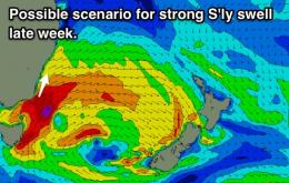
/reports/forecaster-notes/sydney-hunter-illawarra/2016/05/13/small-sly-pulses-more-size-mid-next-week
Guy Dixon
Friday, 13 May 2016
A number of S'ly pulses over the weekend, better energy due mid next week.

/reports/forecaster-notes/sydney-hunter-illawarra/2016/05/11/frequent-sly-pulses-clean-offshore-each
Guy Dixon
Wednesday, 11 May 2016
We've just about seen the last of the E'ly energy, just in time for multiple S'ly pulses. Clean conditions each day this week and each morning thereafter.
/reports/forecaster-notes/sydney-hunter-illawarra/2016/05/09/lwt-encroaching-nsw-swell-window
Guy Dixon
Monday, 9 May 2016
E'ly swell should ease, before our S swell window brings the goods mid-late week.
/reports/forecaster-notes/sydney-hunter-illawarra/2016/05/06/peak-ely-swell-weekend-followed-long
Guy Dixon
Friday, 6 May 2016
E'ly trade-swell peaking on the weekend, with S'ly swell on the cards mid-late next week.
/reports/forecaster-notes/sydney-hunter-illawarra/2016/05/04/small-trade-swell-peaking-over-weekend
Guy Dixon
Wednesday, 4 May 2016
Modest trade-swell peaking this weekend, possible strong S'ly groundswell late next week.
