The run of swell has come to an end, a mediocre week ahead

Sydney, Hunter and Illawarra Surf Forecast by Guy Dixon (issued Monday 29th February)
Best Days: Tuesday and Wednesday morning
Recap:
It was a dynamic weekend right across the east coast of Australia to say the least. Late Saturday afternoon saw the peak in size along the stretch from the Hunter to Illawarra, with open beaches picking up solid 6-8ft sets, with the occasional bigger bombs. South facing beaches offered a more manageable size, but winds weren’t playing ball. An east-southeasterly airflow was established from the get go, leading to pretty ordinary conditions.
However, Sunday was a different story. A light westerly breeze allowed for clean conditions with still plenty of size in the mix, fading from the 4-6ft range throughout the day.
Today, the swell has eased further. We started off with fun, clean 3ft+ sets, however the size is easing and an afternoon seabreeze has gotten into it. We are beginning to see southerly groundswell build across south facing beaches this afternoon generated by a broad frontal progression which crossed the southern Tasman on Sunday, reaching the 2-3ft range at the magnets.
This week (Tuesday 1st - Friday 4th):
The outlook ahead looks pretty meagre, especially in comparison to the run of swell we have been graced with in recent times.
We are in for a mix of swells on Tuesday - the last remnants of easterly groundswell which we saw peak on the weekend and leftover energy from this afternoon’s southerly pulse. The mix of these two swell sources should see most beaches fade from the 2ft+ range, perhaps a touch larger across the Hunter early in the day.
Early offshore breezes look to give way to a northeasterly seabreeze during the morning, so head out earlier rather than later.
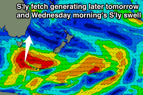 Another pulse of southerly energy is due into the evening Tuesday, easing Wednesday morning which has been generated by south/southwesterly trailing fetches as they moved into our swell window. This small but intense fetch of 50kt winds should lead to a peak overnight on Tuesday evening to 2-3ft, before fading from the 2ft+ range at south facing beaches on Wednesday morning.
Again, a northwesterly breeze is on the cards for the early session, but succumbing to a seabreeze soon after.
Meanwhile, a high pressure ridge has been slowly becoming established over the Tasman sea, steering fairly benign fetches along its eastern and western quarters.
Initially, southeasterly energy is due to fill in across the coast generated by weak fetches along the west coast of New Zealand, providing forgettable options in the 2ft range late on Wednesday, more so on Thursday morning.
More locally, short range northeasterly energy is expected to increase on Thursday to the 2ft range across open beaches steered by a near stationary northeasterly fetch.
The local nature of this northeasterly fetch means that quality will be hard to come by. Protected northern corners will be your best bet on Thursday and Friday, with each morning offering the best chance of a workable wave.
All in all, it’s pretty safe to say that Tuesday and Wednesday will be the days to take advantage of.
This weekend (Saturday 5th - Sunday 6th):
Another small pulse of south/southeasterly energy is due to break across the NSW coast into the weekend generated by east/southeasterly fetches along the southern quadrants a low that has been developing during today south of New Zealand.
The alignment of these fetches have been becoming less favourable with each model update, but we can still expect around 2ft with the peak on Saturday morning.
A local northeasterly airflow looks to persist, adding a small amount of local windswell into the mix to around 1-2ft on Saturday and Sunday.
If you’re desperate, make the most of each morning under a north/northwesterly breeze, with the northern corners offering the best conditions. Don’t expect it to last long however as a northeasterly seabreeze looks to come in early.
Next week (Monday 7th onward):
The outlook for the following week is looking pretty quiet, with insignificant swell sources to match this week. Most spots should ebb and pulse between 1-2ft, perhaps increasing to a low quality 2ft across the open beaches on Tuesday as a local northeasterly fetch increases.
Comments
The southerly swell's looking fun across the coast this morning (besides the Bondi closeouts)..
Still some fun straight lines at Bondi.
was cooking 2-3 foot close of play last night..oosss
Yeah that was the new S'ly pulse from the back-side of the low. Curly fun mid-afternoon.