Fun SE swell and light winds on Thursday and Friday morning

Sydney, Hunter and Illawarra Surf Forecast by Guy Dixon (issued Monday 14th March)
Best Days: Early Thursday and most of Friday morning.
Recap:
Conditions weren’t anything special on Saturday with a north/northeasterly breeze kicking in pretty early and having an impact on a small 2ft swell.
A better pulse of south/southeasterly groundswell then filled in across the NSW coast on Sunday afternoon, bumping the sets up to the 2ft+ range at south swell magnets, while open beaches continued to see around 2ft of east/northeasterly groundswell. This east/northeasterly energy is due to peak later this afternoon, with options in the 3ft range across open beaches.
This week (Tuesday 15th - Friday 18th):
A blocking ridge which has been residing over the Tasman sea over the past few weeks will finally break down on Tuesday, bringing an end to these persistent northerlies.
The first proper change in weeks is due to slowly move up the NSW coast later this afternoon, stalling overnight and continuing on Tuesday. A small and lacklustre southerly windswell is due to build to around 2ft+ by Tuesday afternoon across south facing beaches, but lacking shape and power.
Local south/southeasterly breezes are likely to dominate over the Illawarra and Sydney coasts, although having less impact on the Hunter coast until later in the day. The surf is likely to suffer as a result, with only protected southern corners offering anything resembling a decent wave.
The more substantial swell generated by this set up is a building southeasterly swell steered by southeasterly fetches spanning from southern New Zealand to the NSW coast. Wednesday should see the surf build further to around 3-4ft before peaking on Thursday with options in the 3-4ft+ range at a similar size with perhaps the odd bigger set.
This fetch slightly more favourably aligned to the South Coast, so magnets south of Sydney/Illawarra have the potential to build to a peak of around 4-5ft on Thursday.
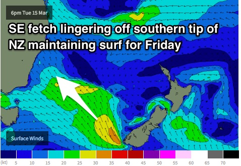
This energy will ease back somewhat on Friday, however the fetches sitting off the southern tip of NZ should maintain options in the 3ft+ range on Friday morning, easing during the day.
Meanwhile, an easterly dip which has been established over the northern Tasman/Coral sea will continue steering an east/northeasterly airflow towards the NSW coast, with the most significant swell generating fetches positioned just south of New Caledonia.
This persistent swell source, although nothing ground breaking should provide a steady flow of trade energy in the 2-3ft range for the open beaches throughout the majority of the week, before the fetch drifts eastwards and intensifies late on Thursday.
Models suggest that a low may develop to just to the northwest of New Zealand’s North Island, which would result in a tightening intensification of east/northeasterly breezes later on Friday.
Again, finding a quality wave will be tricky on Wednesday, with only the outside chance of a brief southwesterly breeze first thing, before becoming southeasterly. Thursday is by far the day of most interest, with early southwesterly breezes looking to be much moire concrete and holding for longer.
As for Friday’s wind outlook, northwesterly breezes look to dominate during the morning, leading to clean groomed conditions, remaining offshore for a good part of the morning, potentially into the afternoon.
This weekend (Saturday 19th - Sunday 20th) and next week (Monday 21st onward):
The resultant easterly energy off the developing low is due to fill in across the open beaches late on the weekend, potentially even into next week with occasional and inconsistent sets breaking in the 3ft range late on Sunday into Monday.
Interestingly, a second round of east/northeasterly trade-swell followed by southerly change and building southeasterly groundswell looks to redevelop once again, with a gusty southerly change looking to whip up the NSW coast with much more vigour on Friday night into Saturday.
This time, the resultant low quality windswell looks to build to around 3-4ft across south facing beaches on Saturday, larger across the Hunter, before the better quality southeasterly swell generated by fetches spanning the southern Tasman peaks on Monday.
More detail on Wednesday.
Comments
Anyone able to pick what swell/s are running sth of Sydney? I reckon ENE, period 11 sec, long wait but some 3 for sets. Just didn't seem like windswell but hard to say. Buoys aren't very helpful either
SE swell from fetch extending from southern NSW to southern NSW should be starting to rival the E/NE now.
Have been finding this buoy more helpful lately.
http://wavewindtide.portauthoritynsw.com.au/Charts
Eden and Sydney had a weird spike in Tp on Mon, you reckon that was anything?
Likely refracted background energy from west/northwest gales which passed over the Southern Ocean, same system which provided swell for Vic coasts on Sunday afternoon. Long periods but no real size.
i reckon it was stronger se swell for sure. was working a few spots that prefer the swell to have a bit more south in it. in saying that however on saturday i think it was, i couldnt quite work out if it was east of south swell so maybe im wrong today. was fun today though.
There was a new S/SE groundswell pulse for Sunday, I was up the coast at a super swell magnet and there were easy 3ft sets into the afternoon.
posted twice
Stating to rival you say. Well then I'll stick with ENE swell that I surfed anyway. As I said seemed like a longer range swell, but you couldn't tell from the buoys. I can backward engineer a SE windswell building over the last few days into it, but you just can't tell if/ when the E swell dies off. Then you can't tell how reliable the data is either, I would've just as easily written off the spike in Tp. Cheers.