Large and powerful swell still on track to peak on Saturday afternoon.

Sydney, Hunter and Illawarra Surf Forecast by Guy Dixon (issued Friday 26th February)
Best Days: Protected southern corners/points on Saturday, then each morning from Sunday.
Recap:
Thursday was a pretty forgettable day with a northeasterly breeze leading to bumpy conditions from the word go. The surf held in the 3ft range throughout the day, but lacked quality.
We have seen a strong kick in east/northeasterly groundswell this afternoon however, with sets now breaking in the 4ft range across open beaches, occasionally bigger. Protected southern corners of the open beaches are offering workable conditions under a moderate southerly airflow, so there are options around if you have the afternoon off.
This weekend (Saturday 27th - Sunday 28th):
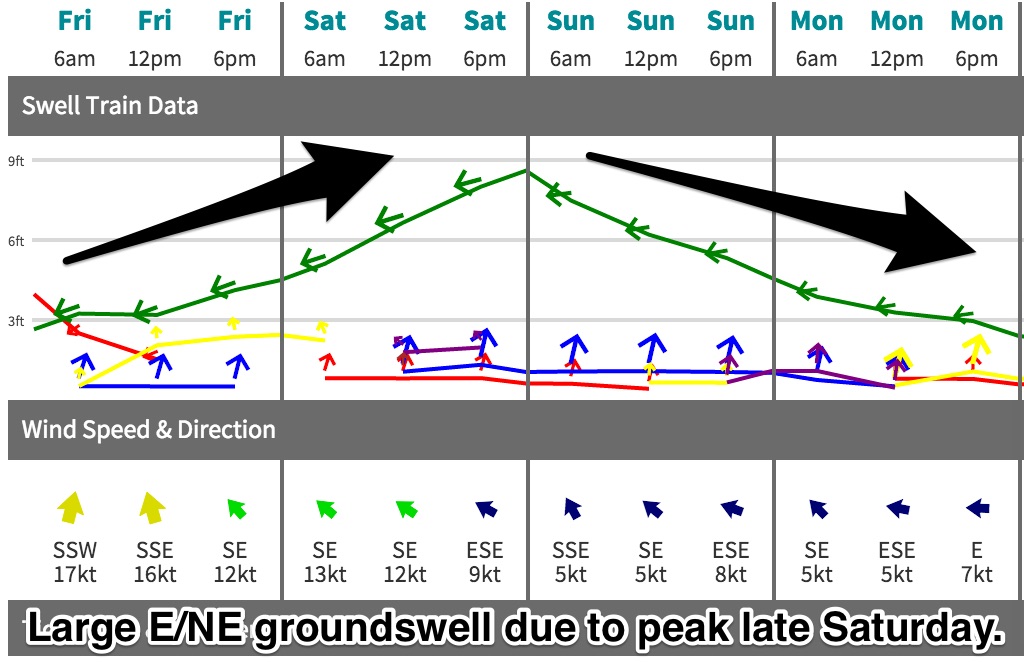 We are still on track to see our strong and powerful groundswell build further across the coast, largest at open beaches.
Over the past week, we have seen a slowly building trend of trade energy generated by the interaction of TC Winston (now Ex-TC Winston) and the associated feeder ridge to the south, but the impacts of Winston itself are beginning to show their face.
This system has been moving in a west/southwesterly motion, steering intense captured fetches along its southern and eastern quadrants. As these intense breezes work on the freshly generated swell, the size compounds and grows rapidly.
It is this energy that we are due to see peak on Saturday afternoon, with open beaches building to the 6-8ft range, larger across the exposed reefs and offshore bombies where sets could break in the 10ft range.
The swell should ease from a similar size from Sunday morning, although the larger sets across the exposed magnets will be becoming less frequent as periods drop.
Following a cooler change easier this morning, much of the NSW coast is now under a southerly component airflow.
As the working week fades into the weekend, this southerly breeze will progressively tend southeasterly while gradually easing. This combo of wind and swell direction will limit options to protected southern corners and points away from the wind.
However the cleaner, more protected spots will also be most exposed to swell direction, so think seriously before paddling out. There will be a lot of water moving around and should only be tackled by experienced board riders.
A smaller, more manageable southerly swell will also be in the water during the weekend generated by the broader scale frontal progression which is associated with this mornings change.
This swell isn’t worth too much of your time however, as the prevailing wind direction will likely take the edge off the quality.
Sunday morning holds the next best chance of workable breezes, with a light southwesterly airflow forecast before giving way to an easterly seabreeze.
Next week (Monday 29th onward):
All swell sources should have well and truely settled down by the start of next week, with residual east/northeasterly energy breaking across the open beaches in the 3-4ft range on Monday, easing throughout the day.
Weak east/northeasterly fetches steered by a building ridge in the wake of Winston should provide small amounts of background energy for the open beaches during the days following, slowly fading to around the 2ft range by Wednesday.
The next most substantial system to generate swell comes in the form of south/southwesterly trailing fetches following a deep low and front on Sunday. Healthy sized 35-40kt south/southwesterly fetches should work on a fairly active sea-state from the days prior, moving east of Tassie and into the NSW swell window on Sunday evening.
The effects of this system won’t be anything overly special, but the south swell magnets should pick up around 2ft+ on Monday afternoon, fading from Tuesday morning.
Meanwhile, a sneaky little polar low looks to set up just off the Antarctic ice shelf, steering small but intense 45kt winds with okay alignment to the NSW coast. South facing beaches hope to see a bonus swell of this system with sets in the 2-3ft range on Wednesday afternoon and Thursday morning, although inconsistent.
By this stage, a ridge should be becoming established over eastern Australia, so light southwesterly breezes are on the cards for each morning early next week. Make it quick however, as easterly seabreezes look to dominate soon after, tending more northeasterly as the week wears on.
Comments
Solid sets starting to push into Manly now.. this has gotta be pushing 6ft or more. Seen plenty of waves breaking at the bombie too.
How much bigger is it going to get this arvo on this manly beach ?
Observations on the North Coast suggest the next swell is running a little behind schedule, but based on current info it seems 6ft to almost 8ft is still possible very late today. Let's hope it doesn't peak overnight.
You're a busy man Ben!
Get in the water.
Good effort from the guys out Bronte sitting in the rip bowl, it was carnage but some guys picked off a couple. Special mention to whoever got the late drop pig dog drainer. Saw a couple of guys get mowed down at Tamma, good for a laugh.
Bloody hell, it looks like it got pretty big in some Southern NSW venues over the weekend. How's this shot from Steve Wall.
And this one too! How big is this?
Yep bomb worthy of tow in
Does this tie in with my obs that the cyclone Pre hitting Fiji produced NE swell that was later acted upon by the post Fiji crossing cyclone / hybrid creating a NE captured fetch ?
Nah, swell pulsed strongly from E/NE Friday afternoon from Winston moving out of New Cal's swell window, then got biggest Saturday afternoon/evening as the captured fetch E/NE groundswell filled in.
Hang on but everyone is saying that it didn't get biggest sat arvo right ? & I had a look at the buoys myself & there wasnt anything to show there . I did ask twice for a buoy reading summary but nobody even could give one which I was a bit disappointed seeing that you would expect someone out of all the crew watching this swell could do ! It seemed the best part of the swell was fri pm !, note I am inexperienced with the eastside buoys .
Here's the trace Cam, biggest Saturday arvo..
Photos of that slab down South were late Sat.
Looks like the sustained peak of Hsig was through Saturday evening too.
Damn you, nighttime!
Thanks for the buoys & summary craig . The buoys I saw were more to the north & noted better period fri arv , but it was a half arsed study I did !
Probably too busy to bother because my buoy was 3.8 @13 with decent wind
Touche, a swell we talked about a week ago in another thread (WA notes I think) :)
Actually fri ours was 4@15 . Couple of solid peaks that day ! Then sat it eased a bit
I'm not sure how fast this swell was travelling, it may be that it peaked on the Goldy Friday arvo, and on the south coast Saturday arvo, as Snapper and that Left slab are over a 1,000km apart (by road so maybe 900km straight line ???).
Yeah Caml sorry mate but this trace is also fairly featureless. I mean, the direction jumped from E to S 90° but no corresponding changes in the period trends. So looking at this, you can't even reallly glean from the graphs alone if a) there was massive Easterly pulses with some S windswell
Or b) does the swing of direction, increase in H, and Hsig point to an ECL spinning up; with small but prolonged E'ly background groundswell energy?