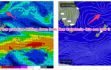
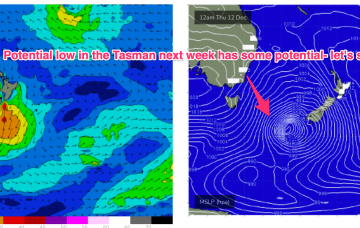
Latest model runs have amplified this trough and a resulting trough of low pressure in the Tasman. There’s still some model divergence to get through so expect some revisions but odds are firming off a sizey S tending S/SE swell event from Wed, as the trough deepens in the Central Tasman.
Primary tabs
/reports/forecaster-notes/sydney-hunter-illawarra/2024/12/13/next-week-now-looking-more-exciting-low
Next week now looking more exciting as low forms in Tasman with some boosting from the South Pacific
freeride76
Friday, 13 December 2024
/reports/forecaster-notes/sydney-hunter-illawarra/2024/12/11/flukey-s-groundswell-short-term
freeride76
Wednesday, 11 December 2024
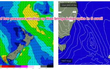
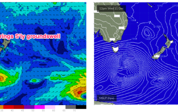
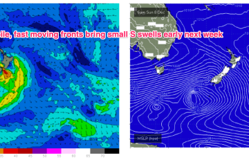
A deep low (962hPa) is currently well to the SW of Tasmania and tracking into the lower Tasman, although being shunted to the SE as it does so. We’ll see some flukey S’ly groundswell from this source. The weak, troughy pattern and mobile high pressure systems extends into next week under current modelling. There are a couple of funky swell sources on the radar during this time frame.
/reports/forecaster-notes/sydney-hunter-illawarra/2024/12/09/sleepy-low-energy-outlook-continues
freeride76
Monday, 9 December 2024
A very weak troughy pattern is unfolding this week with a weak high pressure (1016hPa) cell moving into the Tasman today as a trough stalls about the Far North Coast. Another trough tomorrow brings a shallow S’ly change which again looks to stall out on the North Coast before another weak high cell moves into the Tasman late this week. In short, no major swells expected.
/reports/forecaster-notes/sydney-hunter-illawarra/2024/12/05/low-energy-surf-continues-grovel-hand
freeride76
Friday, 6 December 2024
We’re still looking at a peak in S swell Mon but the frontal passage responsible for it now looks more mobile and poorly aligned so wave heights get a haircut.
/reports/forecaster-notes/sydney-hunter-illawarra/2024/12/04/nothing-major-we-should-see-rideable
freeride76
Wednesday, 4 December 2024
Some decaying and fast moving frontal activity in the lower Tasman is currently scooting across that sea. Once the new high sets up shop in the Tasman we’ll see the N-NE flow which has been a constant for a month reset until another S’ly change arrives on the weekend. No major swells ahead as the pattern of weak, mobile high pressure continues but there’ll be some windows of opportunity with small NE windswell and minor flushes of S swell.
/reports/forecaster-notes/sydney-hunter-illawarra/2024/12/02/troughy-unstable-pattern-continues-small
freeride76
Monday, 2 December 2024
Stability and sunshine will be short-lived for temperate NSW, non-existent for the sub-tropics as another complex trough system moves towards the Eastern Seaboard. That will bring a shallow, troughy change mid-week before weak high pressure moves into the Tasman. No major swells this week, so we’ll be relying on a small trade-swell, which looks to ease off mid-week.
/reports/forecaster-notes/sydney-hunter-illawarra/2024/11/29/workable-swells-the-ne-ene-continue
freeride76
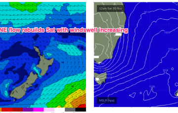
Friday, 29 November 2024
No change to the weekend f/cast. We’ll see the N-NE flow re-strengthen on Sat as a large high slips in under Tasmania and multiple troughs and a cut-off low forming over the interior tighten the pressure gradient along the coast.
/reports/forecaster-notes/sydney-hunter-illawarra/2024/11/27/ne-windswells-continue-some-windows
freeride76
Wednesday, 27 November 2024
The N’ly flow gets briefly disrupted by the trough in temperate areas before resetting again for the weekend, generating more NE windswell.
/reports/forecaster-notes/sydney-hunter-illawarra/2024/11/25/summery-week-end-spring
freeride76
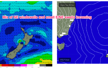
Monday, 25 November 2024
As a result, we’re looking at small NE windswells for temperate NSW, with trade swells for the sub-tropics and a marginal amount of that swell filtering down to temperate regions.
/reports/forecaster-notes/sydney-hunter-illawarra/2024/11/21/small-flukey-swells-dominant-ne-wind-and
freeride76
Friday, 22 November 2024
Slow moving high pressure is drifting in the Central Tasman with a classic summer wind signature of NE winds along temperate NSW, tending more SE-E in the sub-tropics.