Very weak pressure gradients in the Tasman and Coral Seas as we count down 2024.
Primary tabs
/reports/forecaster-notes/sydney-hunter-illawarra/2024/12/30/very-quiet-outlook-minor-windswells
freeride76
Monday, 30 December 2024

/reports/forecaster-notes/sydney-hunter-illawarra/2024/12/27/small-bits-and-pieces-end-the-year
freeride76
Friday, 27 December 2024
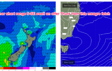
The trough which brings a S’ly change tonight has a brief proximate fetch of strong S-S/SE winds o/night which whips up some local S-SE windswell for Sat. No great size or quality involved.
/reports/forecaster-notes/sydney-hunter-illawarra/2024/12/25/easing-swells-quiet-end-2024
freeride76
Wednesday, 25 December 2024
A deep low is moving slowly towards New Zealand but the main bulk of the fetch has already rotated away from the East Coast with an off axis fetch aimed at South Pacific Islands. Elongated high pressure is moving into the Tasman with an approaching trough, front and cut-off low expected to tighten the pressure gradient leading to freshening N’lies from Boxing Day.

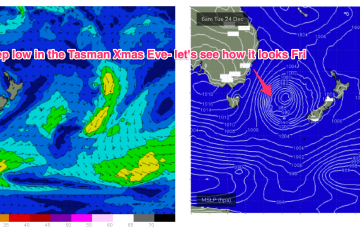
/reports/forecaster-notes/sydney-hunter-illawarra/2024/12/23/santa-brings-sizey-s-swell-xmas-day
freeride76
Monday, 23 December 2024
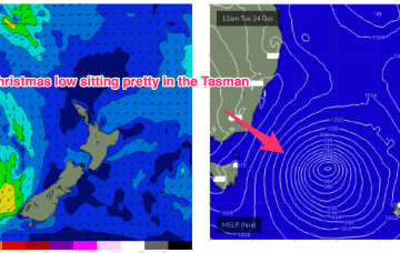
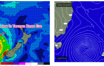
A cold front currently pushing into the Tasman spawns a low pressure system, expected to rapidly deepen later today and o/night before moving slowly in the south-central Tasman.
/reports/forecaster-notes/sydney-hunter-illawarra/2024/12/19/good-waves-the-weekend-and-sizey-s-swell
freeride76
Friday, 20 December 2024
Current ASCAT (satellite windspeed) pass shows a Tasman low with a long fetch of strong S-S/SE winds well positioned in the swell window. Concurrently, weak high pressure is moving NE to be off the sub-tropical coast o/night and into tomorrow morning.
/reports/forecaster-notes/sydney-hunter-illawarra/2024/12/17/quality-sse-swells-ahead-xmas-week
freeride76
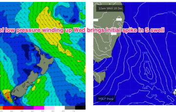
Wednesday, 18 December 2024
This trough of low pressure deepens into a surface low in the Tasman and is expected to track in a northerly direction through the short term. The initial spike in short range S swell will be reinforced by better quality S/SE swells late this week into the weekend.
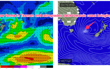
/reports/forecaster-notes/sydney-hunter-illawarra/2024/12/15/active-outlook-week-trough-and-low-form
freeride76
Monday, 16 December 2024
We’ll see some swell from this pattern, first from the initial short range S swell and then some better quality S/SE swell as the surface low retrogrades from near the South Island back into the Tasman.
/reports/forecaster-notes/sydney-hunter-illawarra/2024/12/13/next-week-now-looking-more-exciting-low
Next week now looking more exciting as low forms in Tasman with some boosting from the South Pacific
freeride76
Friday, 13 December 2024
Latest model runs have amplified this trough and a resulting trough of low pressure in the Tasman. There’s still some model divergence to get through so expect some revisions but odds are firming off a sizey S tending S/SE swell event from Wed, as the trough deepens in the Central Tasman.
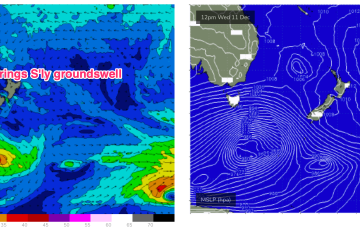
/reports/forecaster-notes/sydney-hunter-illawarra/2024/12/11/flukey-s-groundswell-short-term
freeride76
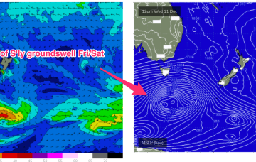
Wednesday, 11 December 2024
A deep low (962hPa) is currently well to the SW of Tasmania and tracking into the lower Tasman, although being shunted to the SE as it does so. We’ll see some flukey S’ly groundswell from this source. The weak, troughy pattern and mobile high pressure systems extends into next week under current modelling. There are a couple of funky swell sources on the radar during this time frame.
/reports/forecaster-notes/sydney-hunter-illawarra/2024/12/09/sleepy-low-energy-outlook-continues
freeride76
Monday, 9 December 2024
A very weak troughy pattern is unfolding this week with a weak high pressure (1016hPa) cell moving into the Tasman today as a trough stalls about the Far North Coast. Another trough tomorrow brings a shallow S’ly change which again looks to stall out on the North Coast before another weak high cell moves into the Tasman late this week. In short, no major swells expected.