Fun swell pulses with tricky winds
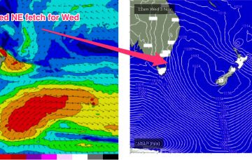
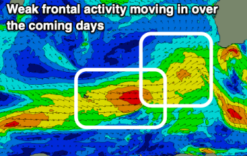
We're looking at better winds for the Margaret River region over the coming period, though still tricky. Further north winds will have a southerly bias as well.
The Mid Coast will offer the cleanest conditions though generally small surf this period, with only a couple of windows down South.
The coming period is fairly average wind wise, but there is one day to focus on.
Easing surf with workable winds over the coming days ahead of a tiny run of swell.
A much stronger intensification of the fetch occurs Wed, as strong to low end gale NE winds develop off Bass Strait, extending up off the Gippsland Coast.
Weak fronts but workable swells over this coming period, worth making the most of before things go quiet next week.
A large (1025 hPa) high pressure system is currently drifting over Central NSW into the Tasman sea and this high pressure cell is expected to track SE, strengthen and become slow moving as it meanders near the South Island for most of this week. That creates a summer-style synoptic pattern, with SE/ESE Tradewinds through the sub-tropics and a N’ly flow through temperate NSW.
Fun windows of waves for both coasts this period, with the Mid Coast being the target later week.
A low pressure system developing north of New Zealand’s North Island drifts south to be over the North Island Wed, and while that blocks most of the fetch from generating swell for the East Coast, it does shoot out a fetch through Cook Strait Wed/Thurs which looks like a tidy source of ESE swell for the region Fri/Sat.
Winds will generally favour the beaches over the coming period with fun pulses of moderate sized + swells.