Limited windows down South, better on the Mid

South Australian Surf Forecast by Craig Brokensha (issued Wednesday November 3rd)
Best Days: Mid Coast for the keen late tomorrow, Mid Coast Friday, Mid Coast Saturday morning, South Coast Friday morning and Saturday morning, Mid Coast later Sunday
Features of the Forecast (tl;dr)
- Low point in swell tomorrow AM with S/SE winds
- Late increase in new W/SW swell tomorrow, peaking through Fri PM, easing slowly Sat
- E (E/NE down South) winds ahead of weak sea breezes Fri, variable Sat ahead of an early afternoon S/SW change, then strengthening
- New W/SW swell for Sun PM with S/SE winds, easing Mon with moderate SW winds
- Secondary S/SW swells Tue/Wed with S/SE-SE winds
Recap
Great waves across the South Coast yesterday with clean 3ft sets in the morning along the Middleton stretch, easing into the afternoon as offshore winds strengthened, backing off later in the day. The Mid Coast was a tiny 1ft through the morning but the incoming tide saw very inconsistent 1-2ft sets showing across the swell magnets.

Inconsistent but good sets yesterday afternoon
This morning the swell was much smaller across both regions with early light winds ahead of an onshore change linked with a trough moving through. The Mid was a bumpy 0.5-1ft with clean 1-2ft waves down South.
This week and weekend (Nov 4 - 7)
Today's change is strengthening as a trough moving in from the west consolidates and this will create poor conditions tomorrow as winds remain moderate out of the S/SE. The swell will also be at a low point so slate in a lay day down South.
 For those on the Mid Coast though, keep your eyes peeled for a late afternoon kick in new, weak W/SW swell.
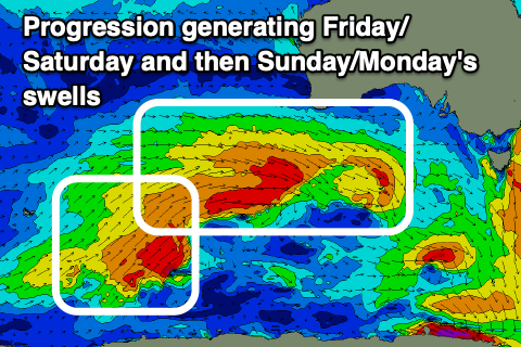
This and a stronger pulse for Friday and Saturday will be generated by a healthy though not overly strong mid-latitude frontal progression pushing through our western swell window.
An initial fetch of strong W-W/NW winds will give way to a stronger gale-force fetch today, passing under Western Australia but a little less favourably aligned for the Mid Coast than was forecast on Monday.
We'll still see fun sets, but it looks to be a little smaller and less consistent.
So coming back to later tomorrow's pulse and we should see 1-1.5ft sets by dark with S/SE winds, while Friday comes in at 1-2ft (most consistent 2ft into the afternoon) with a light to moderate E'ly offshore ahead of weak sea breezes. The South Coast will offer more size with 3ft sets across Middleton on Friday with a morning E/NE breeze ahead of sea breezes.
The swell should start easing Saturday from 1-2ft on the Mid Coast and 2-3ft down South and winds look variable offshore across both coasts before another trough moves in, bringing strengthening S/SW winds from early afternoon.
We'll see strong but abating S/SE winds creating poor conditions down South into Sunday, while the Mid Coast looks fun with a new pulse of mid-period W/SW swell for the afternoon. This will be generated by a trailing weaker front pushing up and under Western Australia Thursday and Friday, keeping 1-2ft sets hitting the swell magnets into the afternoon, easing from a similar size Monday.
The South Coast should build back to 2-3ft, easing from a similar size Monday, but conditions will remain bumpy as another trough swings winds back to the SW, moderate in strength.
Continued, weak polar frontal activity pushing up towards Victoria will preven a high moving in quickly from the west through early next week, stopping winds swinging back to the north. Instead S/SE winds are due Tuesday, fresher E/SE on Wednesday with moderate pulses of mid-period S/SW swell. There might be a window of lighter winds late week, but check back here Wednesday for more on this.