Fun swell pulses with tricky winds

Western Australia Surf Forecast by Craig Brokensha (issued Wednesday November 3rd)
Best Days: Tomorrow morning, Friday morning Perth and Mandurah (protected spots late in the South West), Saturday morning, Sunday morning, Monday morning in the South West
Features of the Forecast (tl;dr)
- Building mid-period SW swell this afternoon, holding tomorrow AM with light E/NE winds in the South West, moderate S/SE further north then shifting SW
- Secondary pulse of mid-period SW swell Thu PM and Fri AM with fresh to strong S/SW tending S winds in the South West Fri (lighter S/SE-SE in Perth and Mandurah through the morning)
- Reinforcing S/SW swell filling in Sat with SE tending S/SW winds in the South West (S/SE in Perth and Mandurah), easing Sun with E/SE-SE tending S/SW winds (S/SE Perth and Mandurah)
- Fading surf Mon with morning E/SE winds
Recap
Poor conditions across all locations yesterday with a drop in weak swell from Monday's increase and strong low, while this morning we've seen favourable winds in Perth and peaky 2ft sets, a little wind affected in Mandurah but still fun. Margs is back to 4-6ft and still bumpy with a moderate onshore wind.
This weekend and next week (Nov 4 - 7)
The first pulse of new, mid-period SW swell is due to fill in this afternoon, generated by an initial weak frontal system projecting up and towards us. The secondary stronger and best swell producer is currently generating an additional fetch of gale-force W-W/NW winds through our swell window and this will produce a better pulse for tomorrow afternoon and Friday morning.
 Size wise, the South West should see 5-6ft sets this afternoon, 2ft+ in Mandurah and 2ft across Perth, holding a similar size tomorrow morning. The stronger swell should pulse to 6ft+, 2-3ft and 2ft+ respectively tomorrow afternoon, easing back from a similar size on Friday.
Winds tomorrow will be better across the South West and variable out of the E/NE, while Perth and Mandurah will see moderate S/SE winds, with SW sea breezes kicking in across all coasts through the day.
Friday looks dicey in the South West with fresh to strong S/SW winds (lighter and S/SE-SE in Perth and Mandurah during the morning), with winds tending S'ly later in the day across the South West.
Cleaner conditions should be seen across all locations on Saturday with a SE wind in the South West (S/SE across Perth and Mandurah) ahead of stronger S/SW sea breezes.
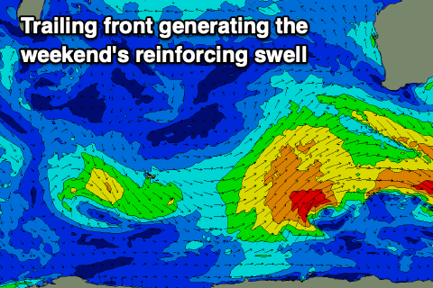 A new pulse of mid-period S/SW swell is due and this looks to be a little stronger than forecast on Monday. The source will be a trailing front on the back of the progression bringing the coming days swell, with a good fetch of strong to gale-force SW winds projected through our south-west and then southern swell windows.
The swell should be in the water from just after dawn, peaking through the day to 6ft+ across the South West, 2ft+ in Mandurah and 2ft across Perth with those winds stated above.
Sunday morning looks really fun as the swell starts to ease under offshore E/SE-SE winds in the South West, S/SE further north.
Monday will be cleaner with an E/SE offshore wind but the swell will be small and easing, with the surf bottoming out through the week due to a large blocking setup developing to our west, as pointed out last update. Therefore try and make the most of the coming swells and windows of decent conditions.