Patchy outlook, but next week has some promise
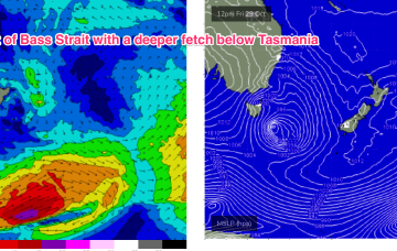
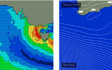
Friday will see developing SE tending S/SW gales, as the low crosses through Bass Strait.
The weekend looks more reliable as the low moves away during Sat, with gales to severe gales on the western flank of the low generating another strong pulse of S swell for Sat. Expect surf in the 3-5ft range during Sat, with fresh W’ly quarter winds during the day.
Eventually the low pressure system tracks into the Tasman, and with an associated front forms a low in the active window E of Tasmania overnight Fri/early Saturday. That will see some new S swell arriving on the weekend.
For now though, the interplay between the approaching low system and high in the Northern Tasman is setting up a N’ly flow which will take us through the to end of the working week.
A trough has moved inland and a mid-latitude low is approaching the SW of the state, bringing an onshore flow that is likely to tend NW to N through tomorrow. The low then crosses the South-West land division on Wed, bringing several wind changes through the day as it moves inland.
Strong onshore winds associated with this cut-off low are likely to dominate the start of the weekend.
There's not much to look forward to this week.
The current synoptic pattern is a low pressure system E of Tasmania directing a fetch of SSW to S strong winds to low end gales adjacent to the NSW South Coast and extending south-east of Tasmania. This low then eases as it moves out into the Tasman sea later today.
The current synoptic pattern is a low pressure system E of Tasmania directing a fetch of SSW to S strong winds to low end gales adjacent to the NSW South Coast. This low then eases as it moves out into the Tasman sea later today.