Fun waves from later week

Western Australian Forecast by Craig Brokensha (issued Monday January 1st)
Best Days: Thursday morning and Friday morning across the South West, Saturday and Sunday in the South West
Features of the Forecast (tl;dr)
- Small, inconsistent W/SW groundswell tomorrow with gusty S/SE-SE winds, stronger S-S/SE into the PM
- Swell fading Wed
- Moderate sized, inconsistent W/SW groundswell filling in Thu with strong but easing E/SE winds ahead of sea breezes mid-PM
- Easing swell Fri with similar winds to Thu
- Small, inconsistent SW groundswell for Sat, peaking in then PM with gusty E winds ahead of mid-PM sea breezes
- Small-moderate sized W/SW swell Sun, peaking in the PM with E/SE tending S/SW winds
Recap
Happy New Year!
Windy, easing surf on the weekend that was best from late morning ahead of sea breezes Saturday, average and bumpy with cross-shore winds yesterday. Perth and Mandurah were tiny.
Today is smaller and wind affected.
This week and weekend (Jan 1 - 7)
Into tomorrow a small pulse of W/SW groundswell is due, generated by a tight but intense low north of the Heard Island late last week. The swell should provide a boost in surf to 4ft across the South West and 1-1.5ft in Perth and Mandurah.
Winds don’t look overly favourable and gusty from the S/SE-SE tomorrow morning ahead of strong S-S/SE sea breezes.
The swell will fade into Wednesday under gusty SE morning winds, better Thursday and straighter from the E/SE (strong) along with a new mix of inconsistent W/SW groundswell energy.
As touched on in Friday’s notes, the source was a good fetch of gale-force W’ly winds to the south-east of the Heard Island region.
The remnants of the storm are now north of the Heard Island region, weak in strength with the groundswell due to arrive through Thursday and peak through the day to an inconsistent 4-6ft in the South West, 1-2ft in Mandurah and 1.5ft across Perth.
The offshore winds should hold until early afternoon ahead of late sea breezes.
The easing trend looks slow with 4-5ft waves across the South West Friday morning, easing through the day under strong but easing E/SE winds ahead of sea breezes.
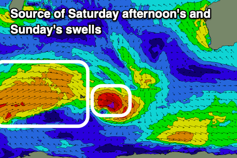
Into the weekend, a small pulse of SW swell is due on Saturday, though the source will be a shore-lived fetch of strong to gale-force W/NW winds to the east of the Heard Island region tomorrow evening. It only looks to generate 4ft sets on the South West magnets.
A trailing front of broader, weaker winds should produce a little more energy into Sunday with consistent surf to 4-5ft or so with tiny 1-1.5ft waves across Mandurah.
Morning winds will continue to be favourable and moderate to fresh from the E Saturday morning, E/SE-SE on Sunday morning. Following this winds will slip back to the S/SE with no major swell sources so try and get a surf in this period.