Easing surf with trickier winds, fun on the weekend

Western Australian Surf Forecast by Craig Brokensha (issued Wednesday December 6th)
Best Days: Saturday morning, Sunday morning for the keen in the South West, Tuesday morning for the keen in the South West, similar Thursday
Features of the Forecast (tl;dr)
- Small, easing swell tomorrow with mod-fresh S/SE-SE tending strong S/SE winds in the South West (strong S/SE early to the north)
- Similar winds Fri
- Moderate sized +, inconsistent SW groundswell for later Fri, peaking early Sat
- Fresh E/SE winds ahead of strong sea breezes Sat
- Easing swell Sun with fresh E-E/NE winds ahead of sea breezes
- Small pulse of SW groundswell for Mon PM with E/NE tending N winds ahead of sea breezes
- Small-moderate sized mid-period W/SW swell building Tue PM, holding Wed with morning E winds ahead of sea breezes Tue
- S/SE-SE tending S/SW winds Wed
Recap
Good waves the last couple of days, with Monday's large W/SW groundswell only easing a touch into yesterday, down to the 6ft+ range in the South West, 2-3ft across Perth and Mandurah.
This morning is cleaner across all locations with a good reinforcing SW swell maintaining 4-6ft sets in the South West, 2-3ft across Mandurah and 2ft in Perth.

Slower but fun sets this AM
This week and next (Dec 7 - 15)
Looking at the end of the week, we've got smaller, easing surf but with less favourable winds, moderate to fresh from the S/SE-SE in the South West tomorrow, strengthening from the S/SE through the day. Winds to the north look strong from early.
Fading 4ft sets are due in the South West, 1-2ft Mandurah and tiny in Perth. Friday morning looks smaller temporarily ahead of a new, inconsistent SW groundswell that's due to arrive through the afternoon, building to peak on Saturday morning.
As talked about on Monday, this was generated by a strong but distant low that formed to the south-east of South Africa on the weekend. A good fetch of gales were produced, with the moderate sized groundswell due to peak Saturday morning to an inconsistent 5-6ft in the South West, 2ft Mandurah and 1-2ft across Perth.
Winds are due to improve on Saturday, shifting E/SE through the morning, fresh in nature and then strong S/SE into the afternoon.
A straighter E-E/NE breeze is due Sunday morning with smaller, fading surf ahead of strong sea breezes.
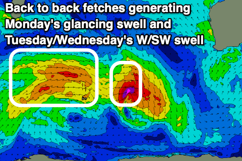
Moving into Monday, a small pulse of glancing SW groundswell is due, generated by a strengthening polar low late in our swell window, with a fetch of pre-frontal W/NW gales expected to produce a kick to 2-3ft in the South West through the day, easing Tuesday. Winds will be great again, E/NE through the morning, tending N ahead of late sea breezes.
A secondary, slightly better but weaker mid-period W/SW swell is due Tuesday afternoon and Wednesday, produced by a weak fetch of strong W-W/NW winds behind the developing low. This should produce a small W/SW swell to 4ft later Tuesday, holding Wednesday in the South West, 1-1.5ft to the north but with afternoon sea breezes, following E morning winds. Wednesday morning should see S/SE-SE winds, cleaner later week as the swell fades.
Longer term there's nothing significant on the cards, but check back Friday for any change to the situation.