Poor run for the South West continues

Western Australia Surf Forecast by Craig Brokensha (issued Monday June 19th)
Best Days: Perth and Mandurah Wednesday morning, Perth and Mandurah Saturday and Sunday mornings
Features of the Forecast (tl;dr)
- Weak, mod-large mid-period S/SW-SW swell building tomorrow PM, peaking Wed
- Strong SW tending S/SW winds tomorrow, S/SW Wednesday (S/SE-SE early Perth and Mandurah)
- Swell building Fri with strong SW winds, peaking Sat with strong S/SW winds (S/SE-SE early Perth and Mandurah)
- Easing swell Sun with gusty S-S/SE winds
- Small Mon with fresh SE winds
Recap
Great conditions across Perth and Mandurah with good sized surf easing back from 2-3ft and 3ft respectively, while the South West was ragged and very average Saturday, still very lumpy and below par yesterday while becoming smaller. A disappointing weekend in all respects while the metro locations faired best again Sunday with fun sets to 2ft.
This morning conditions are much cleaner in the South West but the swell is back to 2-3ft, tiny and clean in the metro locations.
This week and weekend (Jun 20 - 25)
The coming period is looking sub-standard with a weaker progression of frontal system due to bring stormy, onshore waves through the week and weekend, but without the size seen last week and on the weekend just passed.
Currently a weak, broad frontal system is projecting up and into us, with strong SW-S/SW winds due through tomorrow along with building surf, remaining strong from the S/SW on Wednesday with a peak in weak, mid-period energy. Perth and Mandurah should see early S/SE-SE winds but size wise we're looking at poor quality 6-8ft waves in the South West, 2-3ft in Mandurah and 2ft across Perth. The window of favourable winds early Wednesday will be short-lived so make the most of it.
Winds will kick up again from the W/SW on Thursday and be strong thanks to the next progression of frontal systems moving in, and these will have more strengthen with a polar system due to project strong SW tending S/SW winds up and into us Thursday evening.
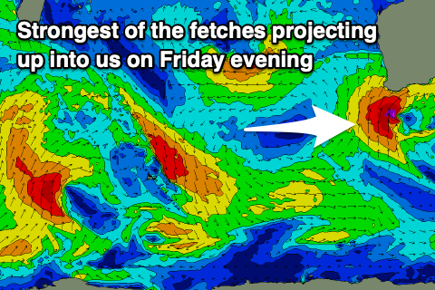
A low pressure centre is then due to form, resulting in a secondary fetch of S/SW gales being projected up into the south of the state later Friday.
This will generate an oversized, stormy S/SW swell for Saturday to the 12ft+ range across the South West, 3-4ft in Mandurah and 2-3ft across Perth.
Unfortunately strong SW winds will accompany the building swell Friday, with Saturday seeing strong S/SW winds persisting in the South West, more variable and S/SE-SE to the north in Perth and Mandurah.
Winds will slowly improve Sunday as the swell continues to ease, though gusty from the S-S/SE in the South West and S/SE to the north, swinging SE on Monday morning though with only small, fading leftovers.
Longer term unfavourable, smaller S/SW swells look to dominate the swell window through next week but we'll have a closer look at this on Wednesday.