Easing surf with some new energy next week

Western Australia Surf Forecast by Craig Brokensha (issued Wednesday January 11th)
Best Days: Tomorrow morning South West magnets, Sunday morning South West magnets for the keen, Tuesday morning, Wednesday morning
Features of the Forecast (tl;dr)
- Small, easing surf tomorrow with E/SE tending S/SW winds
- Smaller Fri with strengthening S-S/SW winds
- Small mid-period SW swell building Sat with strong SE tending S/SE winds
- Easing surf Sun with gusty E/SE tending S/SE winds
- Moderate sized SW swell for Mon with strong S/SE winds
- Larger SW groundswell for Tue with gusty SE tending strong S/SE winds
- Easing swell Wed with gusty E/SE tending S/SE winds
Recap
Early light winds yesterday before conditions deteriorated with a trough and onshore change across all locations. The swell was down on Monday's pulse, while this morning we've got some new reinforcing energy but with less than ideal winds. Semi-protected spots were best in the South West while Perth and Mandurah remained onshore.
This week and weekend (Jan 12 - 15)
Tomorrow morning will be the pick of the end of the week, with conditions expected to improve across exposed spots in the South West with a light E/SE breeze and easing 4ft sets across the magnets.
Perth and Mandurah will be tiny and offer less favourable S/SE winds before sea breezes kick in.
A trough will unfortunately see S tending S/SW winds on Friday as the swell eased further, a lay day.
Moving into the weekend, a small mid-period SW swell is due to build through Saturday though to no major size, generated by a weak fetch of W'ly winds moving through our swell window today.
Strong SE winds will create tricky conditions as the swell builds to 3-4ft in the South West (tiny in Perth and Mandurah). Sunday will be cleaner with a gusty E/SE offshore but small 3-4ft of swell persisting on the coast.
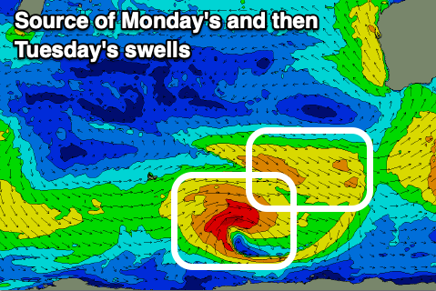
Looking at early next week, fun pulses of SW swell are due across the state, the first for Monday being mid-period energy ahead of some slightly stronger, larger groundswell Tuesday.
The first pulse will be generated by a fetch of pre-frontal W/NW winds around the northern flank of a broad polar low, while trailing strong to gale-force W/SW winds should generate a better groundswell for Tuesday.
Monday's swell should come in at 3-5ft across the South West, tiny in Perth and Mandurah with Tuesday's offering better 6ft sets in the South West, 2ft Mandurah and 1-2ft in Perth.
Winds will unfortunately be poor Sunday as a trough brings strong S/SE winds on Monday, better Tuesday morning and shifting SE, gusty through the morning.
Wednesday will become even cleaner with a gusty E/SE offshore but with smaller, easing surf.
Longer term there's nothing too major expected so try and pencil a surf in around next Tuesday. See you back here Friday.