Less than ideal winds with average conditions

Western Australia Surf Forecast by Craig Brokensha (issued Monday January 9th)
Best Days: Tomorrow morning in the South West and Mandurah, protected spots Wednesday morning for the keen Margs and Mandurah, Thursday morning in the South West
Features of the Forecast (tl;dr)
- Easing SW swell tomorrow, with a reinforcing mid-period swell for later in the day, peaking Wed AM
- Moderate S/SE-SE tending strong S/SW-SW winds tomorrow
- Moderate S winds, tending S/SW (S/SW) from the gert go in Perth and Mandurah
- Easing surf Thu with E/SE tending S/SW winds
- Smaller Fri with S/SE tending strong S/SW winds
- Improving winds on the weekend but with small surf
- Moderate sized SW swell for Mon with gusty S/SE-S winds, slightly stronger Tue AM
Recap
An increase in swell over the weekend but with lumpy, less than ideal conditions Saturday, better yesterday morning with an E/SE-SE offshore. Today we've got another good pulse of mid-period swell with favourable winds before sea breezes kicked in.
Mandurah was around 2ft all weekend and into today, tiny around Perth Saturday and 1-2ft yesterday/today.
This week and weekend (Jan 10 - 15)
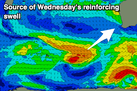
The coming week looks generally small as we see today's mid-period swell easing through tomorrow, slowed slightly by a reinforcing mid-period pulse later Tuesday, peaking Wednesday morning.
This was generated by a good fetch of strong W/NW winds pushing in from the southern Indian Ocean on the weekend.
We should see 4-5ft sets in the South West tomorrow morning, 1-2ft in Mandurah and 1-1.5ft across Perth, with Wednesday coming in around a similar size across all locations. The swell will then start easing into the afternoon, becoming smaller Thursday and Friday.
Locally, winds won't be as favourable tomorrow with a S/SE-SE breeze through the morning ahead of a trough and developing onshore wind late morning, strong from the S/SW-SW into the afternoon/evening.
Wednesday looks dicey with lingering S'ly winds across the South West but only moderate in strength, S/SW to the north. Thursday will become clean again with an E/SE offshore but with smaller, fading surf in size and power.
Winds look to go back to the S/SE on Friday morning as the swell eases further, with a strong S/SW change due to move through into the afternoon.

This will be linked to a weakening front clipping us, though with no new swell to follow it.
Of greater significance is a better polar low moving through our swell window on the weekend.
A fetch of pre-frontal, strong W/NW winds should generate a fun mid-period SW swell for Monday, while a better trailing fetch should generate a stronger groundswell for Tuesday morning.
Winds with these swells look to be out of the southern quadrant and size wise, Tuesday looks to peak around 5-6ft in the South West, 1-2ft in Mandurah and 1-1.5ft across Perth. Nothing too major. Check back Wednesday for more on this swell and what's expected to follow.