Moderate swells inbound with tricky winds

Western Australia Surf Forecast by Craig Brokensha (issued Friday January 6th)
Best Days: Protected spots tomorrow morning Margs and Mandurah, protected spots Sunday morning, Monday morning, Tuesday morning in the South West
Features of the Forecast (tl;dr)
- Moderate sized mid-period SW swell tomorrow with strong but easing S/SE winds ahead of strong S/SW-SW sea breezes
- Easing surf Sun with mod-fresh S/SE tending strong S/SW-SW winds
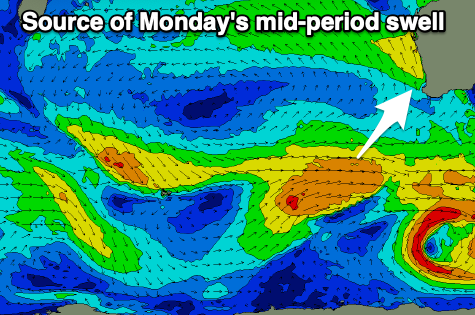
- New moderate sized mid-period SW swell Mon with moderate E/SE-SE winds ahead of sea breezes
- Easing surf Tue with moderate E/SE-SE winds ahead of sea breezes
- New small swell Wed with strong S/SW-S winds
Recap
Hot, windy and clean conditions through yesterday but with a small leftover swell in the South West, tiny to the north. Today conditions were clean early but a trough has since brought a cooler onshore change.
This weekend and next week (Jan 7 - 13)
Today's change is linked to a strengthening mid-latitude frontal progression moving in from the west and an initial tight low has generate a small fetch of SW gales, followed by a broader fetch of strong W/SW winds today.

A mid-period pulse of SW swell is due through tomorrow, peaking later morning to 5-6ft across the South West, 2ft in Mandurah and 1-2ft across Perth into the afternoon.
A temporary drop in size is due through Sunday ahead of a secondary, reinforcing pulse of mid-period SW swell Monday. This will be generated by a secondary front pushing in from the south-west, generating a fetch of strong W/SW winds on top an active sea state.
Sunday looks to ease from 4-5ft in the South West, 1-2ft to the north max, with the pulse Monday kicking back to 5-6ft in the South West, 2ft across Mandurah and a slow 1-2ft in Perth.
Looking at the local winds and a strong but easing S/SE breeze is due tomorrow morning, giving into strong S/SW-SW sea breezes. Sunday looks similar with a moderate to fresh morning S/SE breeze ahead of sea breezes.
Come Monday a better E/SE-SE offshore is due through the morning, moderate in strength before sea breezes kick in late morning/midday, smaller Tuesday and with similar winds.
A small pulse of reinforcing mid-period SW swell is due on Wednesday but below the size of Monday's swell, generated by weaker trailing frontal activity through our swell windows.
A trough moving in from the west looks to bring unfavourable, strong S/SW-S winds though, creating poor conditions.
Longer term unfavourable S/SE winds look to persist through the end of next week and weekend as a stubborn high sets up to our west. This will block our swell windows while also bringing less than favourable conditions.
More on this Monday, have a great weekend!