Large to extra-large swells with poor conditions

Western Australia Surf Forecast by Craig Brokensha (issued Wednesday July 21st)
Best Days: Tomorrow morning in the South West, all day Perth and Mandurah
Features of the Forecast (tl;dr)
- New SW groundswell tomorrow with variable winds (shifting SW into the afternoon in the South West)
- Large onshore surf Sat, Sun and Mon, becoming XL Tue PM and Wed AM, as well as Fri
- Strong onshore winds will persist all next week
Recap
Nice clean conditions across all locations yesterday with Monday's reinforcing swell easing back from 4-5ft in the South West, 2ft in Mandurah and 1-2ft in Perth. Today winds have switched to the S/SE and conditions are OK but the swell smaller and for the keen.
This week and next (Jul 22 - 30)
We've got one more window of light, variable and favourable winds due across the coast tomorrow morning, shifting onshore into the afternoon across the South West but remaining fairly light to the north.
A new, inconsistent SW groundswell is due overnight, peaking tomorrow with fun sets to 4-6ft across the South West but only 1-2ft in Perth and Mandurah. Make the most of the clean conditions as from Friday things will go downhill fast.
As touched on in Wednesday's notes a strong node of the Long Wave Trough firing up and across us next week will direct a series of vigorous and strengthening cold fronts up and into us, generating large to extra-large pulses of swell but with onshore winds.
The first frontal system will project fetches of strong to gale-force SW winds up towards us over the coming days, with the core of the front generating a more consolidated gale-force fetch.
This will generate a large pulse of mid-period SW swell Saturday to the 10ft range in the South West, 3ft+ across Mandurah and 3ft in Perth. Winds will be strong from the W tending SW on Friday as the front moves through, strong W/SW as the swell peaks Saturday.
 Sunday will see strong W'ly winds persisting with the possible window of lighter winds to the north now unlikely. The size will ease a touch ahead of our next pulse of swell Monday.
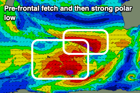
This will be a stronger W/SW groundswell generated by pre-frontal gale to severe-gale W/NW winds sliding in from the west Saturday and Sunday.
Size wise, this fetch looks to produce another strong pulse of groundswell through Monday, building to 10ft+ in the South West, 3-4ft in Mandurah and 3ft across Perth. On top of this into the afternoon though will be windswell from strengthen W/NW tending NW winds ahead of a vigorous cold front attached to a polar low.
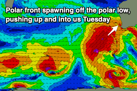 This polar low will fire up behind the pre-frontal fetch of W/NW winds, with a significant fetch of severe-gale W/SW winds due to set in motion an active sea state for stronger severe-gale to storm-force SW winds to move up and over, projecting into us on Tuesday.
An XL mix of long-period groundswell and stormy windswell are due to build Tuesday, easing slowly Wednesday. At this stage the South West looks to kick to 15-20ft or so, 5-6ft in Mandurah and 4-5ft across Perth but with strong W/SW winds, easing into the afternoon.
Easing sets from a similar size are due Wednesday (a bit smaller in Perth and Mandurah) as winds swing to the W/NW and strengthen ahead of another strong frontal system.
This will bring another XL W/SW swell late week but with strong onshore W/SW winds, easing through next weekend but with lingering W'ly breezes. More on this in Friday's update.
Comments
Plenty of swell heading for Indo. The forecast reminds me of a spontaneous Indo trip a few years ago...those were the days....
it's going to be pumping next week!!
Alas that's a way distant dream these days Shaggy