Windy offshore mornings with a couple of good swells

Western Australia Surf Forecast by Craig Brokensha (issued Monday January 3rd)
Best Days: The South West tomorrow morning until mid-afternoon, Wednesday, Thursday morning in the South West, Saturday morning
Features of the Forecast (tl;dr)
- Moderate-large S/SW groundswell for Wednesday with morning E/NE winds
- Inconsistent SW groundswell for Saturday with morning E/NE winds
Recap
A slow start to the weekend but the swell built through Saturday afternoon with favourable offshore winds holding, fun yesterday with windy, easing surf from 3-5ft, tiny to the north but best yesterday morning.
Today we fall in between swells with small surf in the South West, tiny elsewhere.
This week and weekend (Jan 4 - 10)
Windy, breezey morning offshore winds look to dominate the coming week along with afternoons remaining clean for some locales, and one decent groundswell.
A slight lift in mid-period S/SW swell is due tomorrow, generated by persistent weak polar frontal activity through our swell window late last week and Saturday. Size wise we should see sets to 3-5ft across the South West swell magnets, remaining tiny to the north.
Morning offshores will be strong out of the E, easing and tending variable early afternoon across the South West, ahead of sea breezes. Perth and Mandurah look to remain clean all day.
 We then look at the strong, long-period S/SW groundswell due into Wednesday.
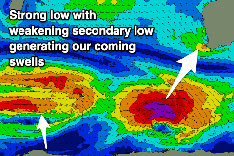
The source of this swell is a strong polar low that's currently just south-southwest of us and moving east out of our swell window.
The low formed around Heard Island Saturday evening and has been generating a great fetch of severe-gale to storm-force W'ly winds through our southern swell window.
This will produce a large, long-period but short-lived S/SW groundswell that's due to peak Wednesday morning with sets to 6-8ft across the South West magnets, 2ft+ in Mandurah and 2ft in Perth.
Gusty E/NE winds will create clean conditions Wednesday morning, easing and tending NE late morning, variable early afternoon ahead of sea breezes. This should provide plenty of opportunity to get a surf or two in Wednesday.
With the short-lived nature of the swell it's worth making the most of as Thursday will likely be back to 4ft in the South West, tiny to the north. Strong E/NE winds will again tend NE and then N/NW ahead of S/SW sea breezes.
 Friday looks smaller again and with the swell bottoming out, select magnets will be best with gusty morning E/NE tending NE winds.
Into Saturday, an inconsistent, long-range SW groundswell is due across the state but the models are incorrectly combining this energy with the existing swell and over-forecasting the raw open ocean size a touch.
The source of this swell is a secondary polar low sitting south-east of South Africa and Madagascar, generating a brief fetch of patchy W-W/NW gales in our far swell window. The low is weakening today, leaving the moderate sized, inconsistent swell to track towards us, arriving later Friday but peaking Saturday morning to an inconsistent 5-6ft across the South West, 2ft in Mandurah and 2ft on the sets in Perth.
Winds look great, moderate to fresh E/NE, swinging more N'ly into the afternoon across the South West, W'ly in Perth, then onshore Sunday as a trough moves through.
Longer term there's nothing too significant on the cards but check back here Wednesday for more of a rundown of next week.
Comments
Just saw this guy thread a perfect, not overly deep but long barrel, nice stall from take-off as well.
And just then saw a guy drop in on someone deep and go over the lip on a 6-8ft'er and nearly land on old mate!!
Bit of carnage at Southside too. Surfer going left went down very hard with the lip.