Upgrade in the expected swells sizes

Victorian Surf Forecast by Craig Brokensha (issued Wednesday 28th June)
Best Days: This morning Surf Coast, Thursday Surf Coast, Friday Surf Coast, early Sunday for the keen Surf Coast, Monday morning exposed coasts, Tuesday
Features of the Forecast (tl;dr)
- Moderate sized mid-period SW swell peaking today, easing tomorrow with strengthening W/NW winds
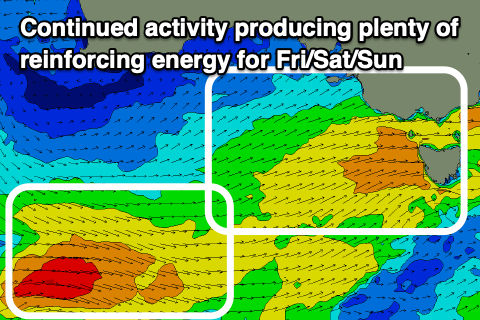
- Moderate sized + mid-period SW swell for Fri with fresh to strong W/NW winds
- Slight drop in swel Sat, with a reinforcing pulse for Sun AM, then easing
- Fresh to strong SW winds Sat (possibly W'ly early Surf Coast)
- Moderate S/SW-S winds Sun (likely W/NW early Surf Coast but lumpy)
- Smaller Mon with variable tending SE winds
- Fun SW groundswell Tue with N tending N/NW-NW winds
Recap
Monday's pulse of localised swell eased back through yesterday with workable conditions across most spots, smallest on the Surf Coast.
Today the swell has come in earlier than expected with clean conditions on the Surf Coast and sets to 3-4ft on the magnets. Winds are due to shift S/SW later morning/midday so make the most of this morning's conditions.
This week and weekend (Jun 29 – Jul 2)
The first pulse of moderate sized, mid-period SW swell has come in early and better than expected with 3-4ft sets on the Surf Coast, and with a bit more period and size due to fill in through the day, 5ft sets are now likely at the swell's peak.
Considering the weak nature of the progression this is a bit of shock, but regardless, it'd be worth getting in this morning ahead of this afternoon's S/SW change.
The swell is due to ease through tomorrow from a similar size, now looking to be 3-4ft on the Surf Coast (5ft sets magnets) and 6ft to the east under strengthening W/NW winds.
This will be associated with the next swell producing front pushing in from the south-west, with it expected to produce a bigger increase in consistent, mid-period energy for Friday.
Seeing today's size, I'm tempted to go a little bigger even though wind strengths aren't anything amazing, with 4-5ft+ sets due on the Surf Coast (odd 6ft'er magnets), 6ft to occasionally 8ft to the east along with fresh to strong, persistent W/NW winds.
Saturday/Sunday look to ease a touch but remain moderate in size thanks to a reinforcing, final front swinging in and along the same track through tomorrow and Friday, with surf to 4ft due to persist on the Surf Coast Saturday, easing from 3-4ft Sunday.
To the east we'll see 6ft waves Saturday, easing back from 5-6ft Sunday.
Winds will unfortunately be less than ideal Saturday as the backside of the front brings fresh to strong SW winds that might be W'ly for a short period in the morning on the Surf Coast. Sunday looks a touch dicey as well with moderate S/SW breezes, likely W/NW early on the Surf Coast but with lumpy conditions thanks to the onshore winds out to sea in Bass Strait.

Monday looks smaller with variable winds opening up cleaner conditions on the exposed beaches ahead of a new pulse of SW groundswell spreading radially off a fetch of gale to severe-gale NW winds projecting towards the polar shelf. This fetch will develop south-west of Western Australia, far enough away from us to see some decent swell spreading in, kicking to the Surf Coast 2-3ft with 4-5ft sets to the east. Winds look to swing back to the N/NW-NW, but we'll hopefully see a brief period of N'ly winds early morning to the east.
Longer term we're looking at W/SW groundswell arriving through later next week, but check back here Friday for the latest.