Solid surf slowly eases through the week with some supporting energy favouring South of the Border

freeride76

Solid surf slowly eases through the week with some supporting energy favouring South of the Border

freeride76

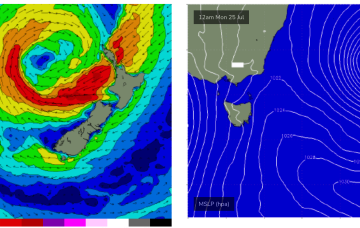
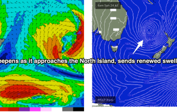
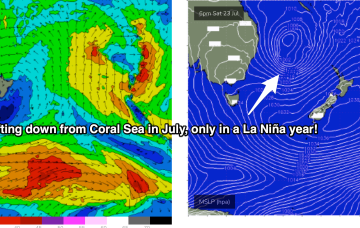
Lovely looking map this morning with the weekend’s Coral Sea low low lingering near the North Island, having intensified overnight. Current ASCAT (satellite windspeed) pass shows storm force winds embedded in a larger fetch of SE-ESE gales to severe gales aimed back (mostly) at NSW.

Coral Sea low drifting south brings solid E/NE swell to Tas from Sun into next week

freeride76

Coral Sea low drifting south brings solid E/NE swell to Tas from Sun into next week

freeride76

The remains of a low near the South Island are continuing to send south quadrant swells towards Tasmania  and, most notably, a trough of low pressure in the Coral Sea is deepening and expected to activate into a fully fledged Coral Sea surface low as an upper trough moves over it from inland QLD tomorrow. This low will provide large E’ly quadrant swells for a huge swathe of the Eastern Seaboard, from the Central QLD Coast to Tasmania over the coming week.