Poor weekend with options to the north

Western Australia Surf Forecast by Craig Brokensha (issued Friday July 22nd)
Best Days: Perth and Mandurah Sunday, early Monday Perth and Mandurah protected spots, Wednesday, Thursday
Features of the Forecast (tl;dr)
- Building windswell tomorrow with strong NW tending SW winds
- XL groundswell building Sun, peaking later with strong but easing SW winds, shifting W in the South West (lighter S/SE-SE in the AM Perth and Mandurah - variable into the afternon Perth)
- Easing swell Mon with strengthening NW winds (mod-fresh N/NE early Perth and Mandurah)
- Strong N/NW tending W/SW winds Tue
- XL groundswell for Wed with variable winds (E'ly offshore in the morning Perth and Mandurah)
- Easing swell Thu with strengthening NE winds
Recap
There was a window of light winds across all locations through yesterday morning as a trough moved across us. Perth and Mandurah were around 2-3ft with 4-5ft sets in the South West, deteriorating after lunch as a stronger onshore wind kicked in.
This morning all locations were onshore and poor but winds have since eased across Perth and Mandurah providing OK waves for the desperate. Winds will increase again from the W/NW this afternoon as the next front approaches.
This weekend and next week (Jul 23 - 29)
We've got back to back XL groundswells due over the coming period as a progression of strong polar fronts push up from the Heard Island region, towards us under the influence of a strong node of the Long Wave Trough.
The first developed west of the Heard Island region yesterday and is now tracking towards us while generating a fetch of severe-gale W/SW winds.
 The front will weaken while pushing up and across us tomorrow afternoon and evening, bringing strong NW tending SW winds into the afternoon. Some localised windswell will build tomorrow but the XL groundswell is due on Sunday, peaking later in the day.
The South West should build to 12ft+ with 3-5ft sets in Mandurah and 4ft sets across Perth later with improving conditions.
The swell generating front will push east on Sunday leaving strong but abating SW winds in the South West, tending W'ly into the afternoon which isn't ideal, S/SE early in Perth and Mandurah tending SW across Mandurah during the day but likely remaining variable in Perth.
The swell will still be large Monday morning but on a downwards trend along with strengthening NW winds ahead of the next polar frontal progression. Perth and Mandurah will likely see a window of early moderate to fresh N/NE winds with easing 3ft to occasionally 4ft sets in Mandurah, 3ft in Perth.
The second frontal progression doesn't look quite as well structured and not as broad but will be acting on the sea state created before it.
This should generate a similar sized swell to later Sunday though the arrival time looks to be set back to Tuesday evening with a peak now due Wednesday morning.
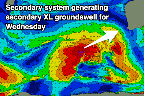 We'll be in between swells on Tuesday and with strong N/NW winds, shifting W/SW into the afternoon as the front clips the state.
Come Wednesday morning, 12ft+ sets are due in the South West, 3-5ft across Mandurah and 3ft in Perth.
Winds should ease and tend more variable through Wednesday as high shifts in from the west, bringing E'ly offshores to Perth and Mandurah ahead of variable sea breezes, likely S/SE early in Margs (check back next week for confirmation).
Winds will quickly shift back to the NE and strengthen on Thursday with easing sets from 8ft in the South West, 3ft in Mandurah and 2-3ft across Perth.
Behind all the activity on the weekend and early next week we've got another strong polar frontal system forecast to project up and towards us, though weaker than the ones before it. It should still generate a large SW swell for later Friday and more so next week but with what looks to be onshore winds. More on this Monday though, have a great weekend!