Fun surf Sunday, stronger west swells next week

South Australian Surf Forecast by Craig Brokensha (issued Friday July 22nd)
Best Days: Sunday morning South Coast, Monday morning South Coast, Wednesday both coasts, Thursday morning South Coast, Friday Mid Coast
Features of the Forecast (tl;dr)
- Low point in swell tomorrow with N winds
- Tiny W swell arriving on the Mid late tomorrow, fading Sun
- Inconsistent SW groundswell Sun, easing later and further Mon
- Moderate N/NE tending fresher NE Sun, stronger N/NW tending W/NW Mon
- Moderate-large W/SW groundswell for Tue with strong but easing SW winds
- Easing W/SW swell Wed with N/NE tending N/NW winds on the Mid, N/NW down South
- Moderate-large W/SW groundswell building later Thu, peaking Fri AM
- Strong NW tending SW winds Thu, SE tending S/SE Fri
Recap
A really fun day of surf across the South Coast's exposed beaches yesterday with persistent 2ft sets across Middleton, smaller today but nice and clean again, ideal for beginners. The Mid Coast has been flat, with bumpy conditions into today.

Whale watchers and fun 2ft surf yesterday afternoon
This weekend and next week (Jul 23 - 29)
The weekend will be one of two halves, tomorrow being a lay day as the swell bottoms out, with Sunday seeing fun surf on the South Coast as a new, inconsistent SW groundswell fills in.
Our small pulse of W'ly swell due for the Mid Coast on Saturday has been downgraded further with the European model winning out as always, with no real quality swell generating fetch being produced by a front moving in from the west yesterday.
At best we'll see a 1-1.5ft wave later tomorrow, easing from 1ft+ Sunday but lower your expectations.
Winds will be out of the N'th tomorrow, creating clean conditions down South (with tiny 1ft surf) and bumpy waves on the Mid Coast.
On Sunday we'll see our inconsistent SW groundswell peaking, generated by a strong polar low that fired up south-west of Western Australia mid-week.
It'll be inconsistent but good, long-lined 3ft sets are due across Middleton, bigger at the more exposed beaches and with N/NE tending fresher NE winds.
Get out before lunch for the best conditions.
Come Monday we'll see the SW groundswell easing from 2ft or so across Middleton and with fresh N/NW tending stronger W/NW winds ahead of an approaching trough.
Now, this trough will be the remnants of a much stronger polar frontal progression that's currently forming around the Heard Island region. We're set to see a flurry of strong polar fronts projecting up towards Western Australia and then through the Bight over the coming days, under the influence of a strong node of the Long Wave Trough.
The first will generate a fetch of severe-gale W/SW winds up through our western swell window, weakening once pushing across Western Australia and passing across us as that trough on Monday evening.
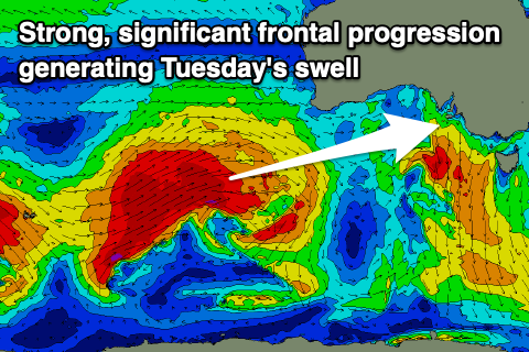 A moderate to large W/SW groundswell will be generated by this first front, arriving later Monday but peaking Tuesday morning with 2-3ft waves on the Mid Coast and 4ft sets across Middleton.
Winds are due to swing SW on Tuesday, in the wake of the trough, strong early and easing a touch later. This will create poor conditions across all locations.
Wednesday looks much better as winds shift back to the NW down South with morning N/NE winds on the Mid Coast as the groundswell eases back from 2ft at Middleton with 3ft+ sets down South across Middleton.
The downwards trend will only be temporary ahead of our next pulse of strong W/SW groundswell on Thursday afternoon and Friday morning.
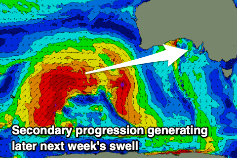 This will be generated by a second strong polar front forming in a similar region but being a little less consolidated and a touch more patchy.
Still, we're expected to see similar sized surf across both regions, building back to 2-3ft later in the day Thursday on the Mid Coast, easing from a similar size Friday.
Middleton should kick to 4ft, and we may see a touch more size on Friday from the remnants of the storm restrengthening south-west of us. More on this Monday.
Looking at the local winds and a pre-frontal NW'ly is due on Thursday ahead of an afternoon SW change, swinging S/SE-SE on Friday as a high moves in from the west, favouring the Mid Coast. Come the weekend we'll see easing but cleaner surf down South as winds shift N/NE. More on this Monday though, have a great weekend!
Comments
Crazy to see how flat it is for the middle of winter!
haven't seen a purple blob this year. Piss poor effort Huey.
Been a strange winter Craig - haven't really had any big swells with offshore winds. Maybe a couple but not many. As soon as it does goes offshore the swell drops out.
I agree seems a bit lacklustre maybe august September might throw up some swell and offshore winds
There actually hasn’t been much wind at all, lots of calm days and nights. Another very strange winter for waves.
Been the same for the last few years. This year has had alot more calm days and easterly winds which is very odd for winter. Seems the swells have been even further north and dipping alot towards south before hitting us. Thankyou Nina bitch
Lots of calm days but It feels like every swell we have had has been accompanied by w or s/w winds
Yep all because they've been more mid -latitude systems not from the roaring forties. So lighter winds but no major size.