Fun, easing swells over the weekend with not much happening next week
Friday, 4 July 2025
Fun, easing swells over the weekend with not much happening next week
Friday, 4 July 2025
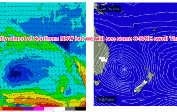
The complex, coastal low is now dissipating and drifting towards New Zealand while high pressure drifts NE to sit over sub-tropical NSW/SEQLD tomorrow before entering the Tasman on Sunday with a broad low pushing across the interior of Victoria and NSW behind it.