Fun swell pulse for Friday

Southern Tasmanian Forecast by Craig Brokensha (issued Wednesday July 2nd)
Best Days: Tomorrow, Friday, Saturday morning, Monday
Features of the Forecast (tl;dr)
- Easing surf tomorrow ahead of a small to moderate sized S/SW swell Fri, easing Sat
- Light W/NW tending W/SW winds tomorrow
- N winds Fri
- N-N/NE winds Sat
- Tiny Sun with N/NW tending variable S winds
- New mid-period SW swell Mon with N/NW winds, easing Tue with strengthening N/NE winds
- Small, inconsistent W/SW groundswell building later Wed with tricky winds
Recap
The surf came in at a fun 2-3ft across Clifton both yesterday and this morning, though onshore winds expected today failed to eventuate. This has resulted in fairly decent conditions regionally.
This week and next (Jul 3 - 11)
We’ve got an easing trend expected into this afternoon and tomorrow before a new pulse of decent sized mid-period S/SW swell fills in for Friday.
This swell has and is still being generated by a drawn out polar fetch of strong to gale-force W/NW winds to our south-west.
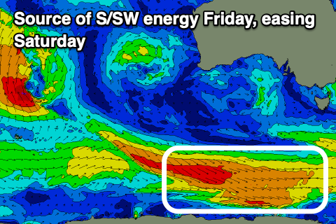
We should see the swell pulsing back to 2-3ft Friday before then easing from 2ft Saturday morning.
Local winds look good tomorrow and variable W/NW tending W/SW with all day N’ly winds Friday.
As the swell eases on Saturday, N-N/NE winds look to persist, tiny Sunday under N/NW offshores, giving into weak if not variable sea breezes.
Into later Sunday but more so Monday, a fun lift in mid-period SW swell is due, generated by a short-lived polar frontal system forming east of the Heard Island region tomorrow. A broad fetch of strong W/NW winds will traverse east and possibly strengthen south of us before leaving the swell window.
A good SW tending S/SW swell is due, peaking to 2ft, easing Tuesday. Winds look offshore most of the day Monday with tiny surf Tuesday under strong N/NE winds.
Looking at the rest of the week, and a strong but northerly located frontal progression is expected to move in under the country through the early stages of the week, bringing with it some tricky W’ly swell.
In saying this, a polar fetch of gale to severe-gale W/SW winds should generate some better aligned W/SW groundswell for Wednesday afternoon.
The outlook from later week looks a bit more productive as all the activity moves further east and across us, but the models are still divergent on how things pan out. More on this Friday.