Fun surf from Friday

Victorian Forecast by Craig Brokensha (issued Wednesday July 2nd)
Best Days: Keen surfers Friday, beaches Saturday morning, keen surfers Tuesday and Wednesday mornings
Features of the Forecast (tl;dr)
- Easing surf tomorrow with pre-dawn onshore winds, easing and tending variable through the AM
- Small-mod sized mid-period S/SW swell for Fri and dawn Sat, easing
- N/NW winds to the west Fri, N/NE to the east
- Strengthening N/NE winds Sat
- Mod-fresh but easing N/NE-NE winds Sun
- Small mid-period SW swell Mon with N/NW-NW winds, possibly tending NE to the east into the PM
- Tiny Tue with strengthening N tending N/NW winds
- Active period from Wednesday onwards
Recap
Onshore winds made a mess of the surf yesterday, while today we’ve still got poor conditions with a gusty S’ly wind, spoiling a couple of good SW groundswell pulses.
This week and next (Jul 3 - 11)
The strong low sitting off the East Coast, responsible for the current onshore winds will continue to influence the local winds and conditions right up until dawn tomorrow.
Onshore breezes are due up until sunrise, easing off and becoming more variable through the morning but we’ll be looking at a lot of lump and noise as today’s groundswell eases.
Friday and Saturday look better for a surf with smaller but cleaner conditions with moderate, local offshore winds expected to shift N/NE into the afternoon while freshening, stronger N/NE through Saturday.
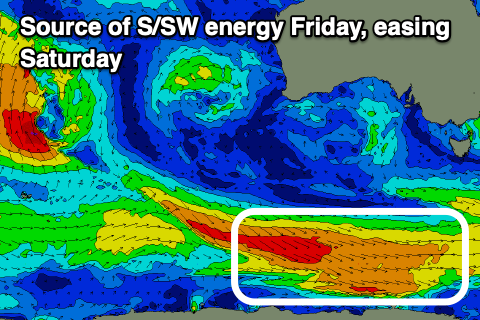
Background levels of mid-period S/SW swell should maintain 2-3ft waves through Friday and early Saturday on the Surf Coast magnets with 3-5ft sets to the east.
These pulses of S/SW energy will be generated by a couple of polar fetches of strong to gale-force W/NW winds today.
The surf will fade through the day Saturday and come in even smaller Sunday with a little less wind, moderate to fresh from the N/NE-NE, easing through the day. All in all a fun run for the beaches.
Now, besides a distant and inconsistent but small long-range groundswell for later Sunday and Monday morning, a slightly better mid-period SW swell is on the cards for Monday, generated by a short-lived polar frontal system forming east of the Heard Island region tomorrow. A broad fetch of strong W/NW winds should kick up a small increase to 2ft+ on the Surf Coast and 4ft to the east under N/NW-NW winds (tending NE into the afternoon to the east).

With the smaller stuff out of the way, we then look to a significant frontal progression moving in through next week, under the influence of a strong node of the Long Wave Trough.
We’re set to see a strong cold outbreak project up and across Western Australia, this Sunday/Monday, likely re-strengthening right on our doorstep Tuesday/Wednesday.
Now, at this stage the activity looks to be right in that range of sitting too high and north of us, generating a sizey but westerly angled swell, with trailing activity later week looking better aligned.
Regardless, the outlook from the middle of next week through the weekend and beyond looks promising.