Cold, windy, wet forecast ahead

Victorian Surf Forecast by Craig Brokensha (issued Monday 7th June)
Best Days: Today, Tuesday
Features of the Forecast (tl;dr)
- Easing mid-period SW swell tomorrow with strong N tending N/NW and then W/NW winds ahead of a late/evening W/SW-SW change
- Inconsistent W/SW groundswell for Wed AM, easing, mixed in with a poor, building S'ly windswell and strengthening S winds
- Easing S windswell Thu, tending SE in direction then easing slowly Fri, small-tiny Sat
- Strong S/SE winds Thu, easing a touch Fri but still fresh from the S into Sat
Recap
A really fun weekend of waves on the Surf Coast with clean conditions and an easing mix of swells from 3ft to occasionally 4ft on the magnets, bigger to the east but bumpy. Conditions were a little cleaner and more workable to the east yesterday, best on the Surf Coast with a slight drop in swell energy.
A new, mid-period W/SW swell filled in through the afternoon and has held in at a good 3ft+ today on the Surf Coast, with a reinforcing SW pulse due to push wave heights up to 3-4ft this afternoon and 6ft to the east though under strong N'ly winds. This is favouring some spots over others.
This week and weekend (Jun 8 - 13)
This afternoon's increase in SW swell should ease back from a similar size tomorrow morning, generated by a good fetch of strong to gale-force W/SW winds moving in under the country on the weekend.
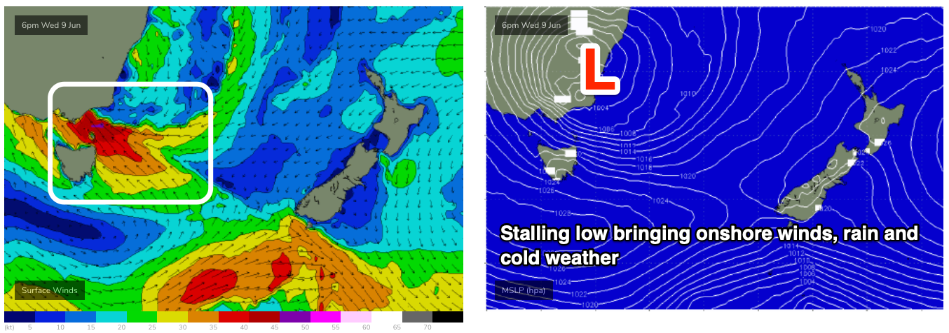
Tomorrow is all about the timing of a shift in winds though as a strong cold front, coming mid-latitude low pushes in slowly from the west. This low will be linked to a deep pool of cold air in the upper atmosphere being projected up from the Southern Ocean, then breaking off and meandering across the south-east of the country all week, bringing lots of rain, cold weather and snow to select alpine peaks over the coming week as it stalls.
The slow movement will favour us tomorrow with winds due to be strong from the N'th at dawn, quickly shifting N/NW by mid-morning and then W/NW by early afternoon, with the onshore change proper out of the W/SW-SW now looking to be after dark. This should provide plenty of options as the swell eases through the day.
Make the most of it though, as once the change moves in, we'll be seeing poor, wet, cold onshore conditions through the rest of the week owing to the lingering nature of the upper cold pool and developing surface low to our south-east.
As the low starts to develop and strengthen we'll see strong S-S/SE winds Wednesday morning, becoming even stronger into the afternoon from the S'th, kicking up a building S'ly windswell to 4-5ft or so during the day across the Surf Coast.
There looks to be some W/SW groundswell for Wednesday morning to 6ft+ on the Mornington Peninsula, generated by the earlier stages of the low as it was a polar system yesterday, south-southwest of Western Australia.
This groundswell will ease through Wednesday afternoon and fade into the end of the week as SE windswell becomes the dominant source of surf.
On Wednesday evening and Thursday morning, gale-force SE winds are expected to be projected into the Gippsland coast and we'll see moderate amounts of SE windswell and even some mid-period E/SE swell likely sneaking in between Flinders Island and the Prom, hitting the southern extents of the Surf Coast.
Size wise it looks like we'll see the S'ly windswell easing from 4-5ft Thursday morning, tending more SE through the day with 3-4ft waves on the Surf Coast Friday, smaller to the east.
Winds will remain poor though and strong from the S/SE Thursday, fresh and S/SE-SE on Friday.
Unfortunately there'll be no relief into the weekend as the low to our east remains stationary through Saturday, Sunday and Monday while slowly weakening and breaking down.
Fresh S'ly winds will persist Saturday with a drop in windswell, more W/SW on Sunday and possibly W/NW for the Surf Coast early but with no swell.
The blocking pattern that the low and corresponding high to our west will put on our swell window means there's no new groundswell due until mid-next week across the state.
This swell looks minimal in any case with distant, mid-latitude frontal activity being the only source of energy for a while.
So all in all the outlook for the coming fortnight is very un-winter like (besides the cold air and snow). Check back over the coming updates for when we may see a switch back to the conditions we saw in April.
Comments
Will this uncommon* weather event have any effect on water temps? Can those strong winds bring water in from the East rather than the usual cold fronts from the West?
* i think
If there was warmer water to bring, possibly.
Looks cooler than normal out east..
Also SE winds would promote upwelling, though the mixed layer through Bass Strait is likely fairly uniform in temperature.
Cold, wet, windy.
Probably best if you don’t apply for a job with tourism Victoria, Craig.
Ha! But rainbows!