Fun run for the beaches

Victorian Surf Forecast by Craig Brokensha (issued Friday January 8th)
Best Days: Beaches mid-morning to early afternoon tomorrow, beaches for the keen Sunday morning, beaches Monday, beaches Wednesday morning
Features of the Forecast (tl;dr)
- Easing, weakening swell on the weekend with variable winds developing Sat AM, light SE Sun AM
- Fun, inconsistent S/SW swell Mon with fresh N/NE winds until late-afternoon
- Building W/SW swell Wed with morning N/NE winds ahead of a S/SW change
Recap
A strong SW groundswell arrived late Wednesday but peaked through yesterday with sets mostly to 4-5ft on the Surf Coast, 6-8ft to the east with workable, light winds during the morning along with a large, dropping tide.
Today the surf is smaller and winds out of the east, favouring selected beaches across the state, though locations east of Melbourne are still mostly too big and hard work.
This weekend and next week (Jan 9 - 15)
Looking at the weekend ahead, and tomorrow morning looks the pick of it with winds tending variable, allowing conditions to clean up before sea breezes kick in.
The surf will continue to ease in size and power, and that morning high tide will create a few issues, but the Mornington Peninsula should still offer 4ft sets early, with 2ft to possibly 3ft waves on the Surf Coast, dropping throug the day.
Dawn won't be great with a light SE'ly, tending variable mid-morning, with sea breezes kicking in midday/early afternoon. So the best of it will likely be that mid-late morning to midday window.
Sunday will be OK for the keen but not as clean as tomorrow with a light SE'ly, possibly going variable for a period, but mostly just remaining from the SE ahead of sea breezes. The swell will be smaller and at a low point as well.
 Moving into next week, and Monday is still shaping up really nicely with offshore winds now likely to hold until the early evening as a trough slowly edges in from the west.
This trough will swing winds to the N/NE on Monday, fresh at times before easing just ahead of the change which looks to be around 6pm or so. A couple of days out this is likely to change a little, so get in your surfs before the evening.
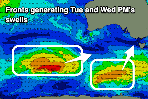
Size wise, a fun though inconsistent, mid-period SW swell should provide a little uptick in energy from Sunday, generated by a polar front that's currently south-southwest of Western Australia. A pre-frontal fetch of strong W/NW winds will be followed by similar strength W/SW winds, producing a SW swell Monday, tending S/SW Tuesday.
It'll be inconsistent but the Surf Coast should see 2ft to occasionally 3ft sets on the swell magnets through Monday/Tuesday, with surf mostly around 4ft on the Mornington Peninsula.
Monday evening's change will leave strong though abating S/SW tending S winds Tuesday, creating average conditions, while another trough moving in quickly from the west should swing wind back to the N/NE on Wednesday morning.
A new mid-period W/SW swell should build through Wednesday, generated by a cold front linked to Monday's late change. Looking back towards the Heard Island region a cold front will intensify this evening, pushing east while generating a fetch of strong to near gale-force W/SW winds. The front will form into a small, weak low, continuing to generate a favourable fetch until Monday afternoon when it races east and weakens.
The swell looks moderate in size, building through Wednesday and peaking into the afternoon with 3ft to possibly 4ft sets likely on the Surf Coast, 5-6ft to the east. The morning will be clean under that N/NE flow, but a trough will bring an onshore change through the afternoon, with onshore winds Thursday as the swell eases.
We may see another low form behind this front generating a small swell for Friday/Saturday but with onshore S/SW winds as a high edges in.
We'll have a closer look at this in Monday's update. Have a great weekend!